You are here: Home > Network List > TA - USArray Transportable Network (new EarthScope stations) Stations List
> Station D35A Remer, MN, USA > Earthquake Result Viewer
D35A Remer, MN, USA - Earthquake Result Viewer
| Earthquake location: |
Near East Coast Of Honshu, Japan |
| Earthquake latitude/longitude: |
37.3/141.8 |
| Earthquake time(UTC): |
2011/03/12 (071) 01:46:20 GMT |
| Earthquake Depth: |
32 km |
| Earthquake Magnitude: |
5.5 MB |
| Earthquake Catalog/Contributor: |
WHDF/NEIC |
|
| Network: |
TA USArray Transportable Network (new EarthScope stations) |
| Station: |
D35A Remer, MN, USA |
| Lat/Lon: |
47.08 N/94.05 W |
| Elevation: |
427 m |
|
| Distance: |
82.3 deg |
| Az: |
34.784 deg |
| Baz: |
318.286 deg |
| Ray Param: |
0.0469668 |
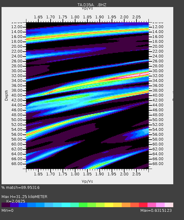
| Estimated Moho Depth: |
31.25 km |
| Estimated Crust Vp/Vs: |
2.06 |
| Assumed Crust Vp: |
6.419 km/s |
| Estimated Crust Vs: |
3.112 km/s |
| Estimated Crust Poisson's Ratio: |
0.35 |
|
| Radial Match: |
89.95316 % |
| Radial Bump: |
400 |
| Transverse Match: |
59.26637 % |
| Transverse Bump: |
400 |
| SOD ConfigId: |
356183 |
| Insert Time: |
2011-08-19 06:16:45.258 +0000 |
| GWidth: |
2.5 |
| Max Bumps: |
400 |
| Tol: |
0.001 |
|

Signal To Noise
| Channel | StoN | STA | LTA |
| TA:D35A: :BHZ:20110312T01:58:07.524985Z | 0.88494986 | 1.5505715E-7 | 1.7521575E-7 |
| TA:D35A: :BHN:20110312T01:58:07.524985Z | 0.4930039 | 1.1899716E-7 | 2.4137165E-7 |
| TA:D35A: :BHE:20110312T01:58:07.524985Z | 0.8330599 | 9.881113E-8 | 1.1861228E-7 |
| Arrivals |
| Ps | 5.3 SECOND |
| PpPs | 15 SECOND |
| PsPs/PpSs | 20 SECOND |


