You are here: Home > Network List > TA - USArray Transportable Network (new EarthScope stations) Stations List
> Station P39A Salisbury, MO, USA > Earthquake Result Viewer
P39A Salisbury, MO, USA - Earthquake Result Viewer

| Earthquake location: |
Near East Coast Of Honshu, Japan |
| Earthquake latitude/longitude: |
37.3/141.8 |
| Earthquake time(UTC): |
2011/03/12 (071) 01:46:20 GMT |
| Earthquake Depth: |
32 km |
| Earthquake Magnitude: |
5.5 MB |
| Earthquake Catalog/Contributor: |
WHDF/NEIC |
|
| Network: |
TA USArray Transportable Network (new EarthScope stations) |
| Station: |
P39A Salisbury, MO, USA |
| Lat/Lon: |
39.49 N/92.75 W |
| Elevation: |
232 m |
|
| Distance: |
88.6 deg |
| Az: |
39.069 deg |
| Baz: |
319.517 deg |
| Ray Param: |
0.042419076 |
| Estimated Moho Depth: |
22.75 km |
| Estimated Crust Vp/Vs: |
1.70 |
| Assumed Crust Vp: |
6.498 km/s |
| Estimated Crust Vs: |
3.816 km/s |
| Estimated Crust Poisson's Ratio: |
0.24 |
|
| Radial Match: |
81.10744 % |
| Radial Bump: |
400 |
| Transverse Match: |
51.422565 % |
| Transverse Bump: |
400 |
| SOD ConfigId: |
356183 |
| Insert Time: |
2011-08-19 06:22:13.041 +0000 |
| GWidth: |
2.5 |
| Max Bumps: |
400 |
| Tol: |
0.001 |
|
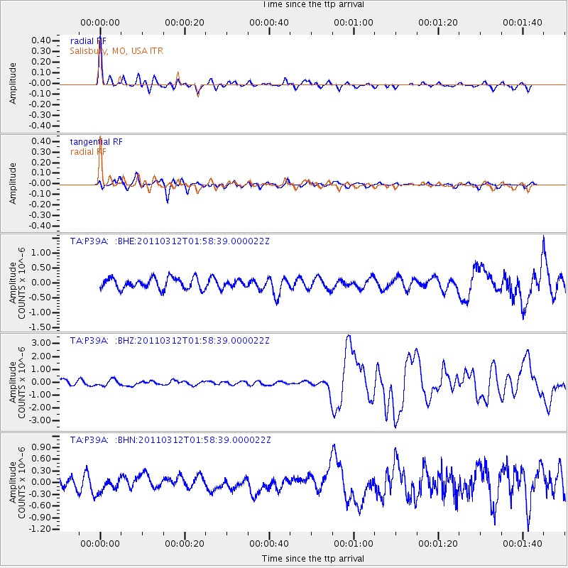
Signal To Noise
| Channel | StoN | STA | LTA |
| TA:P39A: :BHZ:20110312T01:58:39.000022Z | 1.2681049 | 2.467928E-7 | 1.9461545E-7 |
| TA:P39A: :BHN:20110312T01:58:39.000022Z | 0.77401006 | 1.6763671E-7 | 2.1658208E-7 |
| TA:P39A: :BHE:20110312T01:58:39.000022Z | 0.5546624 | 1.0192668E-7 | 1.8376346E-7 |
| Arrivals |
| Ps | 2.5 SECOND |
| PpPs | 9.2 SECOND |
| PsPs/PpSs | 12 SECOND |


