You are here: Home > Network List > TA - USArray Transportable Network (new EarthScope stations) Stations List
> Station R39A Chumby, Stover, MO, USA > Earthquake Result Viewer
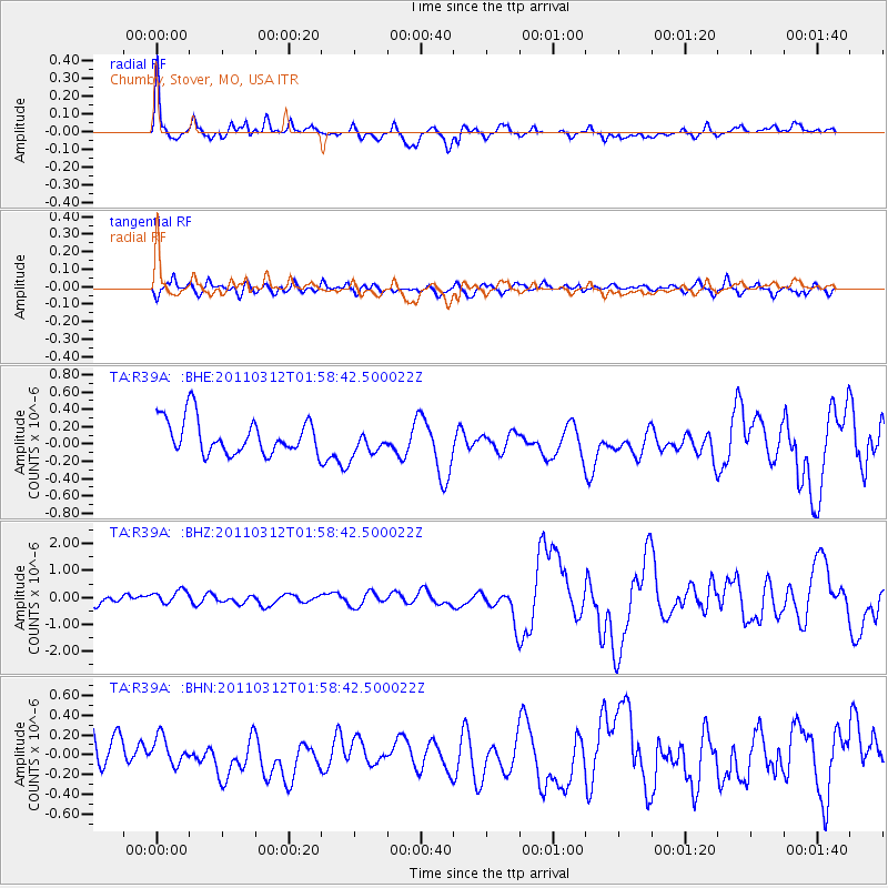
R39A Chumby, Stover, MO, USA - Earthquake Result Viewer
*The percent match for this event was below the threshold and hence no stack was calculated.
| Earthquake location: |
Near East Coast Of Honshu, Japan |
| Earthquake latitude/longitude: |
37.3/141.8 |
| Earthquake time(UTC): |
2011/03/12 (071) 01:46:20 GMT |
| Earthquake Depth: |
32 km |
| Earthquake Magnitude: |
5.5 MB |
| Earthquake Catalog/Contributor: |
WHDF/NEIC |
|
| Network: |
TA USArray Transportable Network (new EarthScope stations) |
| Station: |
R39A Chumby, Stover, MO, USA |
| Lat/Lon: |
38.31 N/93.04 W |
| Elevation: |
290 m |
|
| Distance: |
89.4 deg |
| Az: |
40.0 deg |
| Baz: |
319.356 deg |
| Ray Param: |
$rayparam |
*The percent match for this event was below the threshold and hence was not used in the summary stack. |
|
| Radial Match: |
73.90579 % |
| Radial Bump: |
400 |
| Transverse Match: |
47.54774 % |
| Transverse Bump: |
400 |
| SOD ConfigId: |
356183 |
| Insert Time: |
2011-08-19 06:22:57.570 +0000 |
| GWidth: |
2.5 |
| Max Bumps: |
400 |
| Tol: |
0.001 |
|
Signal To Noise
| Channel | StoN | STA | LTA |
| TA:R39A: :BHZ:20110312T01:58:42.500022Z | 1.5098224 | 2.9246834E-7 | 1.9371043E-7 |
| TA:R39A: :BHN:20110312T01:58:42.500022Z | 0.8160009 | 1.5212437E-7 | 1.8642673E-7 |
| TA:R39A: :BHE:20110312T01:58:42.500022Z | 0.77178 | 1.5596575E-7 | 2.0208577E-7 |
| Arrivals |
| Ps | |
| PpPs | |
| PsPs/PpSs | |


