You are here: Home > Network List > TA - USArray Transportable Network (new EarthScope stations) Stations List
> Station S38A Stockton, MO, USA > Earthquake Result Viewer
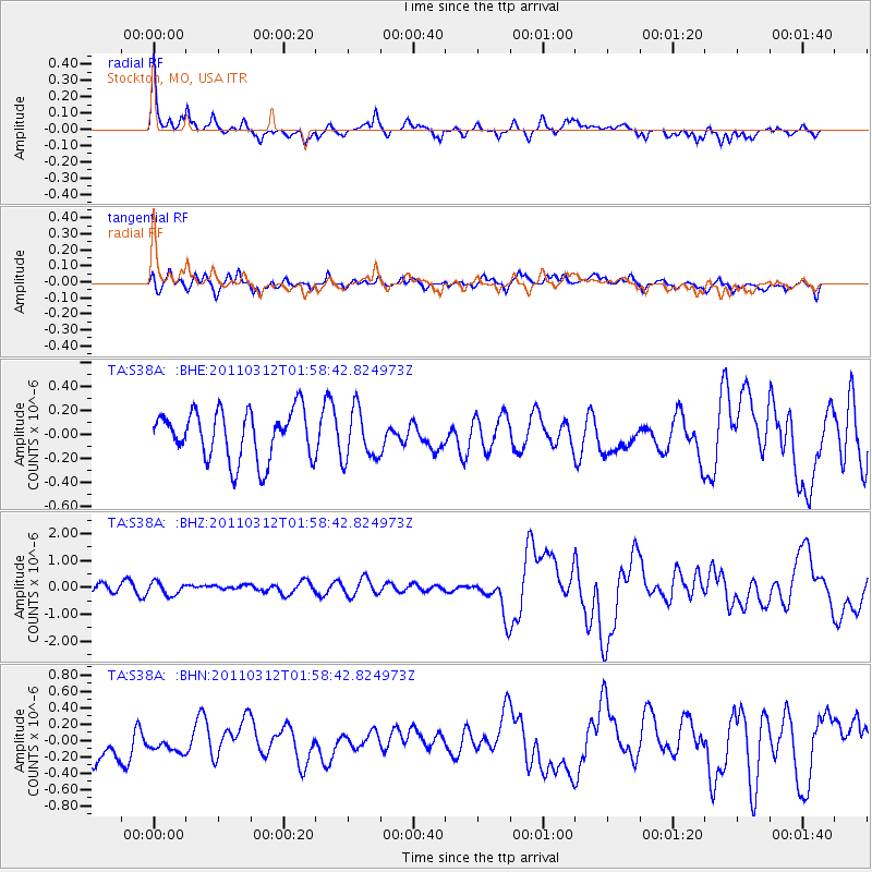
S38A Stockton, MO, USA - Earthquake Result Viewer

| Earthquake location: |
Near East Coast Of Honshu, Japan |
| Earthquake latitude/longitude: |
37.3/141.8 |
| Earthquake time(UTC): |
2011/03/12 (071) 01:46:20 GMT |
| Earthquake Depth: |
32 km |
| Earthquake Magnitude: |
5.5 MB |
| Earthquake Catalog/Contributor: |
WHDF/NEIC |
|
| Network: |
TA USArray Transportable Network (new EarthScope stations) |
| Station: |
S38A Stockton, MO, USA |
| Lat/Lon: |
37.63 N/93.91 W |
| Elevation: |
294 m |
|
| Distance: |
89.4 deg |
| Az: |
40.966 deg |
| Baz: |
318.834 deg |
| Ray Param: |
0.041823547 |
| Estimated Moho Depth: |
61.5 km |
| Estimated Crust Vp/Vs: |
1.94 |
| Assumed Crust Vp: |
6.53 km/s |
| Estimated Crust Vs: |
3.362 km/s |
| Estimated Crust Poisson's Ratio: |
0.32 |
|
| Radial Match: |
80.67582 % |
| Radial Bump: |
372 |
| Transverse Match: |
58.920082 % |
| Transverse Bump: |
400 |
| SOD ConfigId: |
356183 |
| Insert Time: |
2011-08-19 06:24:38.822 +0000 |
| GWidth: |
2.5 |
| Max Bumps: |
400 |
| Tol: |
0.001 |
|
Signal To Noise
| Channel | StoN | STA | LTA |
| TA:S38A: :BHZ:20110312T01:58:42.824973Z | 1.127688 | 2.3238724E-7 | 2.0607405E-7 |
| TA:S38A: :BHN:20110312T01:58:42.824973Z | 0.8345712 | 1.6511353E-7 | 1.9784237E-7 |
| TA:S38A: :BHE:20110312T01:58:42.824973Z | 1.0437555 | 2.1173567E-7 | 2.0285944E-7 |
| Arrivals |
| Ps | 9.1 SECOND |
| PpPs | 27 SECOND |
| PsPs/PpSs | 36 SECOND |


