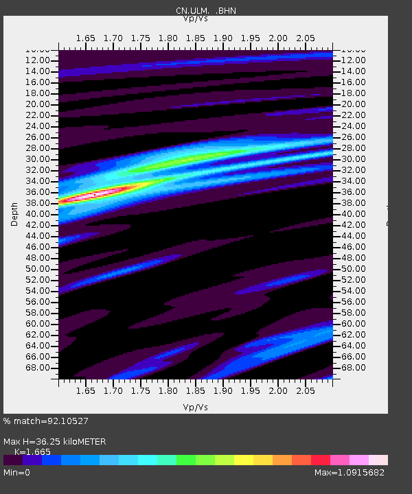
ULM LAC DU BONNET, MB, CANADA - Earthquake Result Viewer
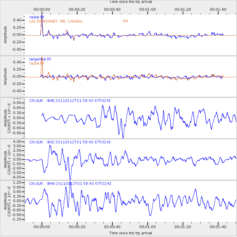
Earthquake location: Off East Coast Of Honshu, Japan
Earthquake latitude/longitude: 37.6/142.6
Earthquake time(UTC): 2011/03/12 (071) 01:47:15 GMT
Earthquake Depth: 20 km
Earthquake Magnitude: 6.2 MB, 6.4 MS, 6.5 MW, 6.5 MW
Earthquake Catalog/Contributor: WHDF/NEIC
Network: CN Canadian National Seismograph Network
Station: ULM LAC DU BONNET, MB, CANADA
Lat/Lon: 50.25 N/95.87 W
Elevation: 251 m
Distance: 78.5 deg
Az: 33.969 deg
Baz: 316.264 deg
Ray Param: 0.0495865
Estimated Moho Depth: 36.25 km
Estimated Crust Vp/Vs: 1.66
Assumed Crust Vp: 6.459 km/s
Estimated Crust Vs: 3.88 km/s
Estimated Crust Poisson's Ratio: 0.22
Radial Match: 92.10527 %
Radial Bump: 400
Transverse Match: 73.07269 %
Transverse Bump: 400
SOD ConfigId: 356183
Insert Time: 2011-08-19 07:07:52.986 +0000
GWidth: 2.5
Max Bumps: 400
Tol: 0.001

Signal To Noise

ChannelStoNSTALTA
CN:ULM: :BHZ:20110312T01:58:43.675024Z14.3118441.8391204E-61.2850339E-7
CN:ULM: :BHN:20110312T01:58:43.675024Z4.994035.5941E-71.1201575E-7
CN:ULM: :BHE:20110312T01:58:43.675024Z2.6703634.0776516E-71.5270027E-7
Arrivals
Ps3.9 SECOND
PpPs14 SECOND
PsPs/PpSs18 SECOND