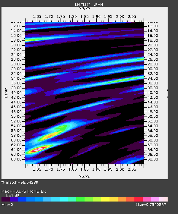
TKM2 KN.TKM2 - Earthquake Result Viewer
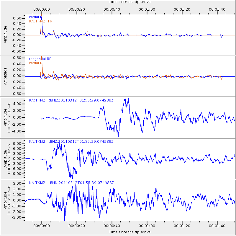
Earthquake location: Off East Coast Of Honshu, Japan
Earthquake latitude/longitude: 37.6/142.6
Earthquake time(UTC): 2011/03/12 (071) 01:47:15 GMT
Earthquake Depth: 20 km
Earthquake Magnitude: 6.2 MB, 6.4 MS, 6.5 MW, 6.5 MW
Earthquake Catalog/Contributor: WHDF/NEIC
Network: KN Kyrgyz Seismic Telemetry Network
Station: TKM2 KN.TKM2
Lat/Lon: 42.92 N/75.60 E
Elevation: 2020 m
Distance: 50.2 deg
Az: 298.35 deg
Baz: 72.111 deg
Ray Param: 0.06817063
Estimated Moho Depth: 63.75 km
Estimated Crust Vp/Vs: 1.65
Assumed Crust Vp: 6.306 km/s
Estimated Crust Vs: 3.822 km/s
Estimated Crust Poisson's Ratio: 0.21
Radial Match: 96.54289 %
Radial Bump: 335
Transverse Match: 84.06437 %
Transverse Bump: 400
SOD ConfigId: 356183
Insert Time: 2011-08-19 07:24:52.545 +0000
GWidth: 2.5
Max Bumps: 400
Tol: 0.001

Signal To Noise

ChannelStoNSTALTA
KN:TKM2: :BHZ:20110312T01:55:39.074988Z9.8800782.964898E-63.0008852E-7
KN:TKM2: :BHN:20110312T01:55:39.074988Z2.96583965.7249247E-71.9302881E-7
KN:TKM2: :BHE:20110312T01:55:39.074988Z5.67469841.4389598E-62.5357468E-7
Arrivals
Ps7.0 SECOND
PpPs25 SECOND
PsPs/PpSs32 SECOND