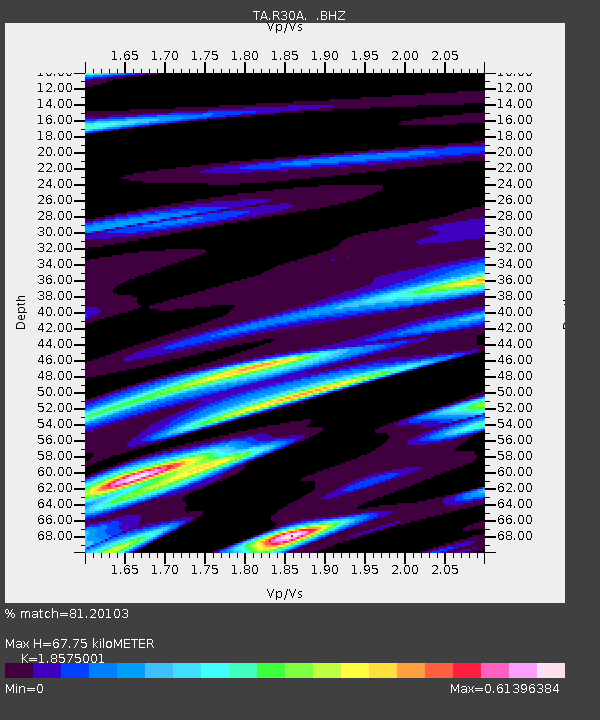
R30A Dighton, KS, USA - Earthquake Result Viewer
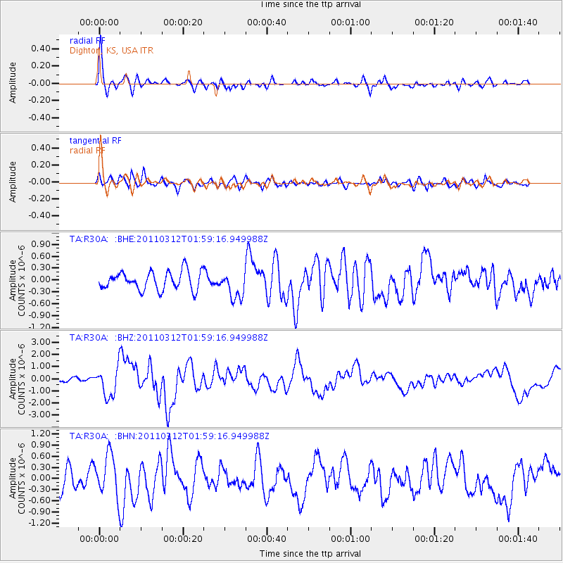
Earthquake location: Off East Coast Of Honshu, Japan
Earthquake latitude/longitude: 37.6/142.6
Earthquake time(UTC): 2011/03/12 (071) 01:47:15 GMT
Earthquake Depth: 20 km
Earthquake Magnitude: 6.2 MB, 6.4 MS, 6.5 MW, 6.5 MW
Earthquake Catalog/Contributor: WHDF/NEIC
Network: TA USArray Transportable Network (new EarthScope stations)
Station: R30A Dighton, KS, USA
Lat/Lon: 38.28 N/100.28 W
Elevation: 776 m
Distance: 84.8 deg
Az: 44.716 deg
Baz: 314.75 deg
Ray Param: 0.045191422
Estimated Moho Depth: 67.75 km
Estimated Crust Vp/Vs: 1.86
Assumed Crust Vp: 6.483 km/s
Estimated Crust Vs: 3.49 km/s
Estimated Crust Poisson's Ratio: 0.30
Radial Match: 81.20103 %
Radial Bump: 372
Transverse Match: 72.723045 %
Transverse Bump: 400
SOD ConfigId: 356183
Insert Time: 2011-08-19 07:48:15.693 +0000
GWidth: 2.5
Max Bumps: 400
Tol: 0.001

Signal To Noise

ChannelStoNSTALTA
TA:R30A: :BHZ:20110312T01:59:16.949988Z6.8976751.20726E-61.750242E-7
TA:R30A: :BHN:20110312T01:59:16.949988Z2.22643185.72081E-72.569497E-7
TA:R30A: :BHE:20110312T01:59:16.949988Z1.47818033.4297983E-72.3202841E-7
Arrivals
Ps9.2 SECOND
PpPs29 SECOND
PsPs/PpSs38 SECOND