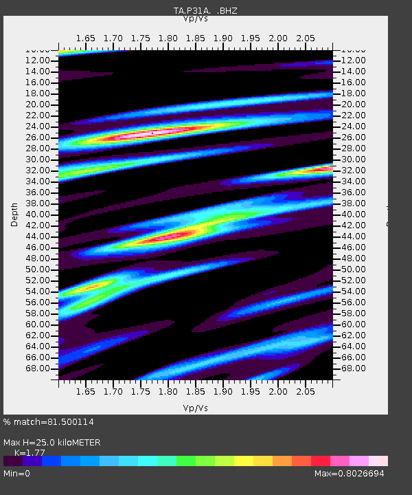
P31A Stockton, KS, USA - Earthquake Result Viewer
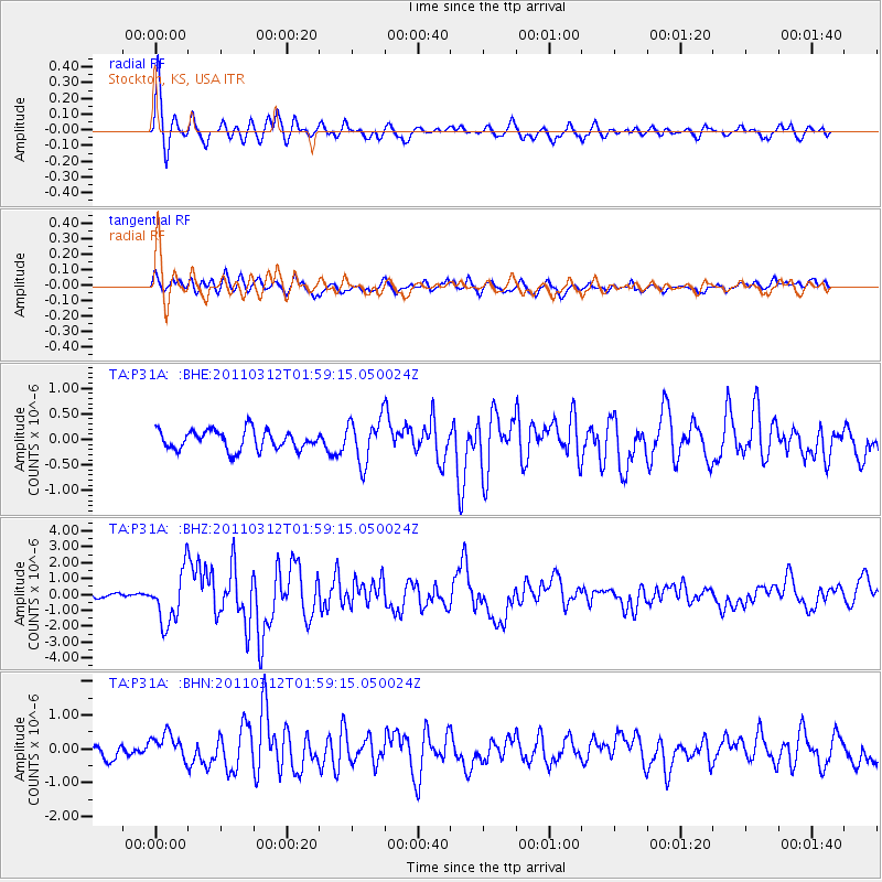
Earthquake location: Off East Coast Of Honshu, Japan
Earthquake latitude/longitude: 37.6/142.6
Earthquake time(UTC): 2011/03/12 (071) 01:47:15 GMT
Earthquake Depth: 20 km
Earthquake Magnitude: 6.2 MB, 6.4 MS, 6.5 MW, 6.5 MW
Earthquake Catalog/Contributor: WHDF/NEIC
Network: TA USArray Transportable Network (new EarthScope stations)
Station: P31A Stockton, KS, USA
Lat/Lon: 39.52 N/99.38 W
Elevation: 665 m
Distance: 84.4 deg
Az: 43.341 deg
Baz: 315.184 deg
Ray Param: 0.045462098
Estimated Moho Depth: 25.0 km
Estimated Crust Vp/Vs: 1.77
Assumed Crust Vp: 6.483 km/s
Estimated Crust Vs: 3.662 km/s
Estimated Crust Poisson's Ratio: 0.27
Radial Match: 81.500114 %
Radial Bump: 400
Transverse Match: 69.04028 %
Transverse Bump: 400
SOD ConfigId: 356183
Insert Time: 2011-08-19 07:53:42.014 +0000
GWidth: 2.5
Max Bumps: 400
Tol: 0.001

Signal To Noise

ChannelStoNSTALTA
TA:P31A: :BHZ:20110312T01:59:15.050024Z10.8904791.6305246E-61.497202E-7
TA:P31A: :BHN:20110312T01:59:15.050024Z1.56782624.1279944E-72.6329414E-7
TA:P31A: :BHE:20110312T01:59:15.050024Z2.2587574.3115685E-71.9088233E-7
Arrivals
Ps3.0 SECOND
PpPs10 SECOND
PsPs/PpSs13 SECOND