You are here: Home > Network List > TA - USArray Transportable Network (new EarthScope stations) Stations List
> Station N30A Hueftle Ranch, Cozad, NE, USA > Earthquake Result Viewer
N30A Hueftle Ranch, Cozad, NE, USA - Earthquake Result Viewer
| Earthquake location: |
Off East Coast Of Honshu, Japan |
| Earthquake latitude/longitude: |
37.6/142.6 |
| Earthquake time(UTC): |
2011/03/12 (071) 01:47:15 GMT |
| Earthquake Depth: |
20 km |
| Earthquake Magnitude: |
6.2 MB, 6.4 MS, 6.5 MW, 6.5 MW |
| Earthquake Catalog/Contributor: |
WHDF/NEIC |
|
| Network: |
TA USArray Transportable Network (new EarthScope stations) |
| Station: |
N30A Hueftle Ranch, Cozad, NE, USA |
| Lat/Lon: |
40.80 N/100.10 W |
| Elevation: |
842 m |
|
| Distance: |
83.2 deg |
| Az: |
42.827 deg |
| Baz: |
314.665 deg |
| Ray Param: |
0.04637363 |
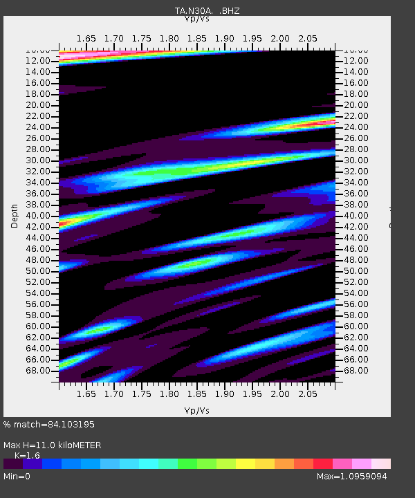
| Estimated Moho Depth: |
11.0 km |
| Estimated Crust Vp/Vs: |
1.60 |
| Assumed Crust Vp: |
6.483 km/s |
| Estimated Crust Vs: |
4.052 km/s |
| Estimated Crust Poisson's Ratio: |
0.18 |
|
| Radial Match: |
84.103195 % |
| Radial Bump: |
400 |
| Transverse Match: |
76.363205 % |
| Transverse Bump: |
400 |
| SOD ConfigId: |
356183 |
| Insert Time: |
2011-08-19 07:54:41.880 +0000 |
| GWidth: |
2.5 |
| Max Bumps: |
400 |
| Tol: |
0.001 |
|

Signal To Noise
| Channel | StoN | STA | LTA |
| TA:N30A: :BHZ:20110312T01:59:08.499976Z | 3.7491698 | 1.4883641E-6 | 3.9698497E-7 |
| TA:N30A: :BHN:20110312T01:59:08.499976Z | 1.1623578 | 6.2894844E-7 | 5.410971E-7 |
| TA:N30A: :BHE:20110312T01:59:08.499976Z | 1.162528 | 5.9357353E-7 | 5.1058856E-7 |
| Arrivals |
| Ps | 1.0 SECOND |
| PpPs | 4.3 SECOND |
| PsPs/PpSs | 5.3 SECOND |


