You are here: Home > Network List > TA - USArray Transportable Network (new EarthScope stations) Stations List
> Station K29A Lazy Trails Angus Ranch, Wood Lake, NE, USA > Earthquake Result Viewer
K29A Lazy Trails Angus Ranch, Wood Lake, NE, USA - Earthquake Result Viewer
| Earthquake location: |
Off East Coast Of Honshu, Japan |
| Earthquake latitude/longitude: |
37.6/142.6 |
| Earthquake time(UTC): |
2011/03/12 (071) 01:47:15 GMT |
| Earthquake Depth: |
20 km |
| Earthquake Magnitude: |
6.2 MB, 6.4 MS, 6.5 MW, 6.5 MW |
| Earthquake Catalog/Contributor: |
WHDF/NEIC |
|
| Network: |
TA USArray Transportable Network (new EarthScope stations) |
| Station: |
K29A Lazy Trails Angus Ranch, Wood Lake, NE, USA |
| Lat/Lon: |
42.76 N/100.32 W |
| Elevation: |
840 m |
|
| Distance: |
81.7 deg |
| Az: |
41.529 deg |
| Baz: |
314.348 deg |
| Ray Param: |
0.04741332 |
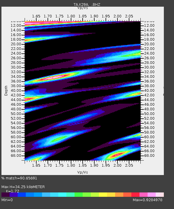
| Estimated Moho Depth: |
34.25 km |
| Estimated Crust Vp/Vs: |
1.72 |
| Assumed Crust Vp: |
6.483 km/s |
| Estimated Crust Vs: |
3.769 km/s |
| Estimated Crust Poisson's Ratio: |
0.24 |
|
| Radial Match: |
90.65691 % |
| Radial Bump: |
398 |
| Transverse Match: |
75.64432 % |
| Transverse Bump: |
400 |
| SOD ConfigId: |
356183 |
| Insert Time: |
2011-08-19 07:56:13.509 +0000 |
| GWidth: |
2.5 |
| Max Bumps: |
400 |
| Tol: |
0.001 |
|

Signal To Noise
| Channel | StoN | STA | LTA |
| TA:K29A: :BHZ:20110312T01:59:00.725012Z | 8.850229 | 1.5419919E-6 | 1.7423186E-7 |
| TA:K29A: :BHN:20110312T01:59:00.725012Z | 2.8101501 | 8.1492715E-7 | 2.8999418E-7 |
| TA:K29A: :BHE:20110312T01:59:00.725012Z | 1.1642076 | 4.947274E-7 | 4.2494773E-7 |
| Arrivals |
| Ps | 3.9 SECOND |
| PpPs | 14 SECOND |
| PsPs/PpSs | 18 SECOND |


