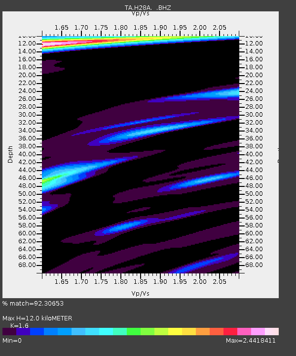
H28A Mission Ridge, SD, USA - Earthquake Result Viewer
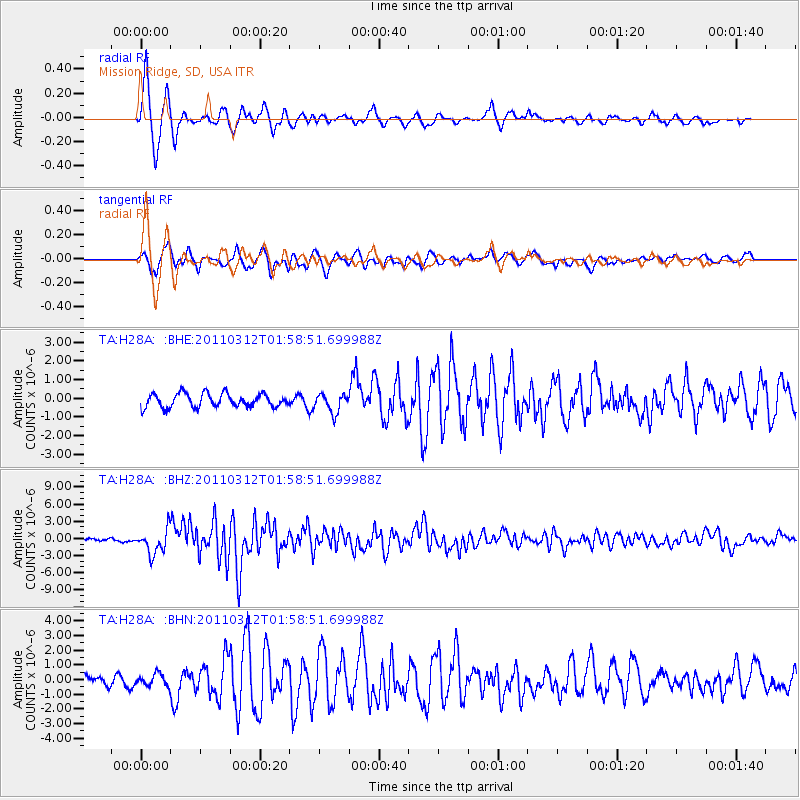
Earthquake location: Off East Coast Of Honshu, Japan
Earthquake latitude/longitude: 37.6/142.6
Earthquake time(UTC): 2011/03/12 (071) 01:47:15 GMT
Earthquake Depth: 20 km
Earthquake Magnitude: 6.2 MB, 6.4 MS, 6.5 MW, 6.5 MW
Earthquake Catalog/Contributor: WHDF/NEIC
Network: TA USArray Transportable Network (new EarthScope stations)
Station: H28A Mission Ridge, SD, USA
Lat/Lon: 44.68 N/101.02 W
Elevation: 642 m
Distance: 80.0 deg
Az: 40.494 deg
Baz: 313.699 deg
Ray Param: 0.04858316
Estimated Moho Depth: 12.0 km
Estimated Crust Vp/Vs: 1.60
Assumed Crust Vp: 6.53 km/s
Estimated Crust Vs: 4.082 km/s
Estimated Crust Poisson's Ratio: 0.18
Radial Match: 92.30653 %
Radial Bump: 400
Transverse Match: 79.489105 %
Transverse Bump: 400
SOD ConfigId: 356183
Insert Time: 2011-08-19 07:59:51.076 +0000
GWidth: 2.5
Max Bumps: 400
Tol: 0.001

Signal To Noise

ChannelStoNSTALTA
TA:H28A: :BHZ:20110312T01:58:51.699988Z10.8711462.1451724E-61.9732715E-7
TA:H28A: :BHN:20110312T01:58:51.699988Z0.743074243.9772598E-75.3524394E-7
TA:H28A: :BHE:20110312T01:58:51.699988Z1.40885935.088833E-73.6120238E-7
Arrivals
Ps1.1 SECOND
PpPs4.6 SECOND
PsPs/PpSs5.8 SECOND