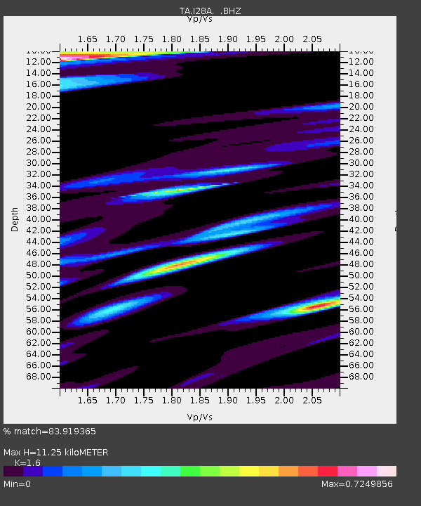
I28A Midland, SD, USA - Earthquake Result Viewer
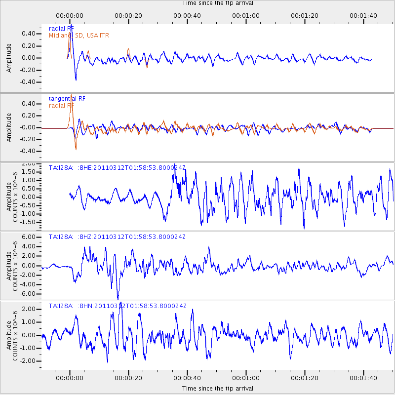
Earthquake location: Off East Coast Of Honshu, Japan
Earthquake latitude/longitude: 37.6/142.6
Earthquake time(UTC): 2011/03/12 (071) 01:47:15 GMT
Earthquake Depth: 20 km
Earthquake Magnitude: 6.2 MB, 6.4 MS, 6.5 MW, 6.5 MW
Earthquake Catalog/Contributor: WHDF/NEIC
Network: TA USArray Transportable Network (new EarthScope stations)
Station: I28A Midland, SD, USA
Lat/Lon: 44.00 N/101.17 W
Elevation: 655 m
Distance: 80.4 deg
Az: 41.065 deg
Baz: 313.693 deg
Ray Param: 0.048316907
Estimated Moho Depth: 11.25 km
Estimated Crust Vp/Vs: 1.60
Assumed Crust Vp: 6.483 km/s
Estimated Crust Vs: 4.052 km/s
Estimated Crust Poisson's Ratio: 0.18
Radial Match: 83.919365 %
Radial Bump: 400
Transverse Match: 71.82092 %
Transverse Bump: 400
SOD ConfigId: 356183
Insert Time: 2011-08-19 07:59:53.665 +0000
GWidth: 2.5
Max Bumps: 400
Tol: 0.001

Signal To Noise

ChannelStoNSTALTA
TA:I28A: :BHZ:20110312T01:58:53.800024Z7.13021851.7534461E-62.459176E-7
TA:I28A: :BHN:20110312T01:58:53.800024Z2.15545237.625735E-73.5378815E-7
TA:I28A: :BHE:20110312T01:58:53.800024Z2.44980056.6433387E-72.7117875E-7
Arrivals
Ps1.1 SECOND
PpPs4.4 SECOND
PsPs/PpSs5.4 SECOND