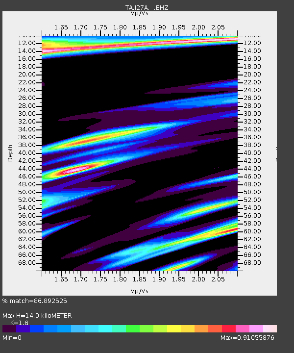
I27A Quinn, SD, USA - Earthquake Result Viewer
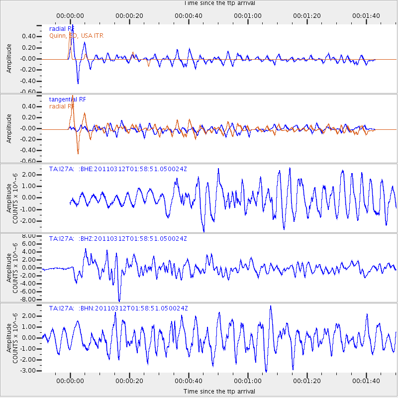
Earthquake location: Off East Coast Of Honshu, Japan
Earthquake latitude/longitude: 37.6/142.6
Earthquake time(UTC): 2011/03/12 (071) 01:47:15 GMT
Earthquake Depth: 20 km
Earthquake Magnitude: 6.2 MB, 6.4 MS, 6.5 MW, 6.5 MW
Earthquake Catalog/Contributor: WHDF/NEIC
Network: TA USArray Transportable Network (new EarthScope stations)
Station: I27A Quinn, SD, USA
Lat/Lon: 44.07 N/102.05 W
Elevation: 867 m
Distance: 79.8 deg
Az: 41.458 deg
Baz: 313.149 deg
Ray Param: 0.048665833
Estimated Moho Depth: 14.0 km
Estimated Crust Vp/Vs: 1.60
Assumed Crust Vp: 6.242 km/s
Estimated Crust Vs: 3.901 km/s
Estimated Crust Poisson's Ratio: 0.18
Radial Match: 86.892525 %
Radial Bump: 378
Transverse Match: 76.712524 %
Transverse Bump: 400
SOD ConfigId: 356183
Insert Time: 2011-08-19 08:00:28.316 +0000
GWidth: 2.5
Max Bumps: 400
Tol: 0.001

Signal To Noise

ChannelStoNSTALTA
TA:I27A: :BHZ:20110312T01:58:51.050024Z11.2019061.6933022E-61.5116198E-7
TA:I27A: :BHN:20110312T01:58:51.050024Z1.91558568.725872E-74.555198E-7
TA:I27A: :BHE:20110312T01:58:51.050024Z1.86014697.421585E-73.9897844E-7
Arrivals
Ps1.4 SECOND
PpPs5.7 SECOND
PsPs/PpSs7.0 SECOND