You are here: Home > Network List > TA - USArray Transportable Network (new EarthScope stations) Stations List
> Station B28A Dugan Ranch, Towner, ND, USA > Earthquake Result Viewer
B28A Dugan Ranch, Towner, ND, USA - Earthquake Result Viewer
| Earthquake location: |
Off East Coast Of Honshu, Japan |
| Earthquake latitude/longitude: |
37.6/142.6 |
| Earthquake time(UTC): |
2011/03/12 (071) 01:47:15 GMT |
| Earthquake Depth: |
20 km |
| Earthquake Magnitude: |
6.2 MB, 6.4 MS, 6.5 MW, 6.5 MW |
| Earthquake Catalog/Contributor: |
WHDF/NEIC |
|
| Network: |
TA USArray Transportable Network (new EarthScope stations) |
| Station: |
B28A Dugan Ranch, Towner, ND, USA |
| Lat/Lon: |
48.45 N/100.36 W |
| Elevation: |
451 m |
|
| Distance: |
77.7 deg |
| Az: |
37.39 deg |
| Baz: |
313.574 deg |
| Ray Param: |
0.050134942 |
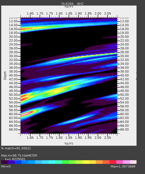
| Estimated Moho Depth: |
59.75 km |
| Estimated Crust Vp/Vs: |
1.62 |
| Assumed Crust Vp: |
6.438 km/s |
| Estimated Crust Vs: |
3.968 km/s |
| Estimated Crust Poisson's Ratio: |
0.19 |
|
| Radial Match: |
91.85521 % |
| Radial Bump: |
392 |
| Transverse Match: |
68.4685 % |
| Transverse Bump: |
400 |
| SOD ConfigId: |
356183 |
| Insert Time: |
2011-08-19 08:09:30.732 +0000 |
| GWidth: |
2.5 |
| Max Bumps: |
400 |
| Tol: |
0.001 |
|
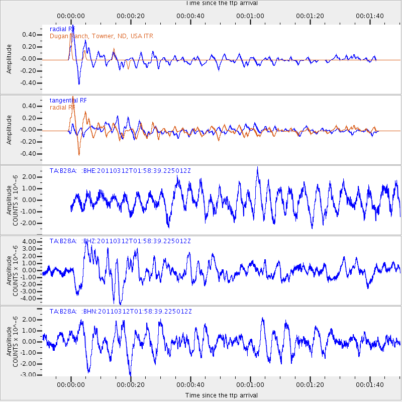
Signal To Noise
| Channel | StoN | STA | LTA |
| TA:B28A: :BHZ:20110312T01:58:39.225012Z | 7.2063503 | 1.8626803E-6 | 2.5847763E-7 |
| TA:B28A: :BHN:20110312T01:58:39.225012Z | 2.3786917 | 1.0929575E-6 | 4.5947843E-7 |
| TA:B28A: :BHE:20110312T01:58:39.225012Z | 1.9303861 | 9.578741E-7 | 4.9620854E-7 |
| Arrivals |
| Ps | 6.0 SECOND |
| PpPs | 24 SECOND |
| PsPs/PpSs | 30 SECOND |


