You are here: Home > Network List > TA - USArray Transportable Network (new EarthScope stations) Stations List
> Station C28A Hausauer Farms, Kief, ND, USA > Earthquake Result Viewer
C28A Hausauer Farms, Kief, ND, USA - Earthquake Result Viewer
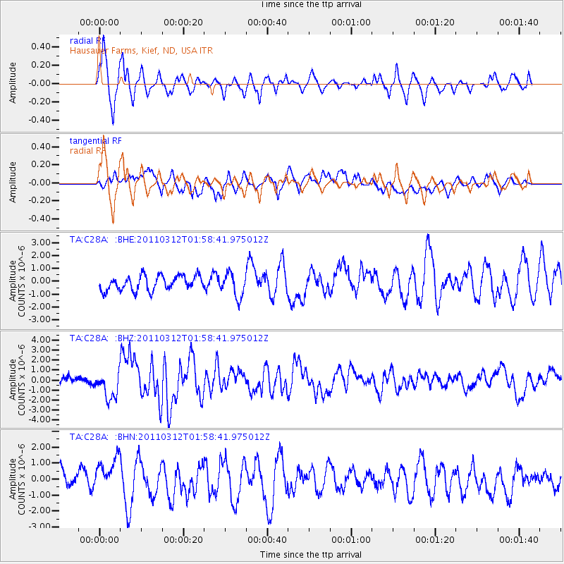
| Earthquake location: |
Off East Coast Of Honshu, Japan |
| Earthquake latitude/longitude: |
37.6/142.6 |
| Earthquake time(UTC): |
2011/03/12 (071) 01:47:15 GMT |
| Earthquake Depth: |
20 km |
| Earthquake Magnitude: |
6.2 MB, 6.4 MS, 6.5 MW, 6.5 MW |
| Earthquake Catalog/Contributor: |
WHDF/NEIC |
|
| Network: |
TA USArray Transportable Network (new EarthScope stations) |
| Station: |
C28A Hausauer Farms, Kief, ND, USA |
| Lat/Lon: |
47.72 N/100.39 W |
| Elevation: |
524 m |
|
| Distance: |
78.2 deg |
| Az: |
37.945 deg |
| Baz: |
313.672 deg |
| Ray Param: |
0.049798567 |
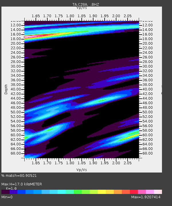
| Estimated Moho Depth: |
17.0 km |
| Estimated Crust Vp/Vs: |
1.60 |
| Assumed Crust Vp: |
6.438 km/s |
| Estimated Crust Vs: |
4.023 km/s |
| Estimated Crust Poisson's Ratio: |
0.18 |
|
| Radial Match: |
80.90521 % |
| Radial Bump: |
400 |
| Transverse Match: |
52.640957 % |
| Transverse Bump: |
400 |
| SOD ConfigId: |
356183 |
| Insert Time: |
2011-08-19 08:10:13.937 +0000 |
| GWidth: |
2.5 |
| Max Bumps: |
400 |
| Tol: |
0.001 |
|
Signal To Noise
| Channel | StoN | STA | LTA |
| TA:C28A: :BHZ:20110312T01:58:41.975012Z | 6.073667 | 1.3996491E-6 | 2.3044548E-7 |
| TA:C28A: :BHN:20110312T01:58:41.975012Z | 1.6248524 | 1.1829503E-6 | 7.2803556E-7 |
| TA:C28A: :BHE:20110312T01:58:41.975012Z | 1.6662741 | 9.4679723E-7 | 5.6821216E-7 |
| Arrivals |
| Ps | 1.6 SECOND |
| PpPs | 6.6 SECOND |
| PsPs/PpSs | 8.3 SECOND |


