You are here: Home > Network List > TA - USArray Transportable Network (new EarthScope stations) Stations List
> Station B30A Myrvik Farm, Edmore, ND, USA > Earthquake Result Viewer
B30A Myrvik Farm, Edmore, ND, USA - Earthquake Result Viewer
| Earthquake location: |
Off East Coast Of Honshu, Japan |
| Earthquake latitude/longitude: |
37.6/142.6 |
| Earthquake time(UTC): |
2011/03/12 (071) 01:47:15 GMT |
| Earthquake Depth: |
20 km |
| Earthquake Magnitude: |
6.2 MB, 6.4 MS, 6.5 MW, 6.5 MW |
| Earthquake Catalog/Contributor: |
WHDF/NEIC |
|
| Network: |
TA USArray Transportable Network (new EarthScope stations) |
| Station: |
B30A Myrvik Farm, Edmore, ND, USA |
| Lat/Lon: |
48.45 N/98.33 W |
| Elevation: |
480 m |
|
| Distance: |
78.7 deg |
| Az: |
36.424 deg |
| Baz: |
314.893 deg |
| Ray Param: |
0.04947567 |
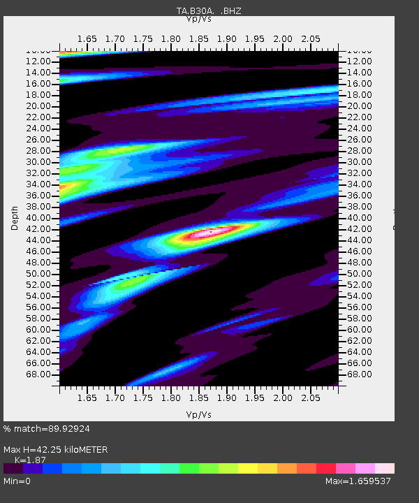
| Estimated Moho Depth: |
42.25 km |
| Estimated Crust Vp/Vs: |
1.87 |
| Assumed Crust Vp: |
6.53 km/s |
| Estimated Crust Vs: |
3.492 km/s |
| Estimated Crust Poisson's Ratio: |
0.30 |
|
| Radial Match: |
89.92924 % |
| Radial Bump: |
400 |
| Transverse Match: |
75.57307 % |
| Transverse Bump: |
400 |
| SOD ConfigId: |
356183 |
| Insert Time: |
2011-08-19 08:10:57.151 +0000 |
| GWidth: |
2.5 |
| Max Bumps: |
400 |
| Tol: |
0.001 |
|

Signal To Noise
| Channel | StoN | STA | LTA |
| TA:B30A: :BHZ:20110312T01:58:44.574988Z | 12.30132 | 2.0293048E-6 | 1.6496644E-7 |
| TA:B30A: :BHN:20110312T01:58:44.574988Z | 1.8611113 | 7.119317E-7 | 3.8253046E-7 |
| TA:B30A: :BHE:20110312T01:58:44.574988Z | 1.8614467 | 5.6087754E-7 | 3.013127E-7 |
| Arrivals |
| Ps | 5.8 SECOND |
| PpPs | 18 SECOND |
| PsPs/PpSs | 24 SECOND |


