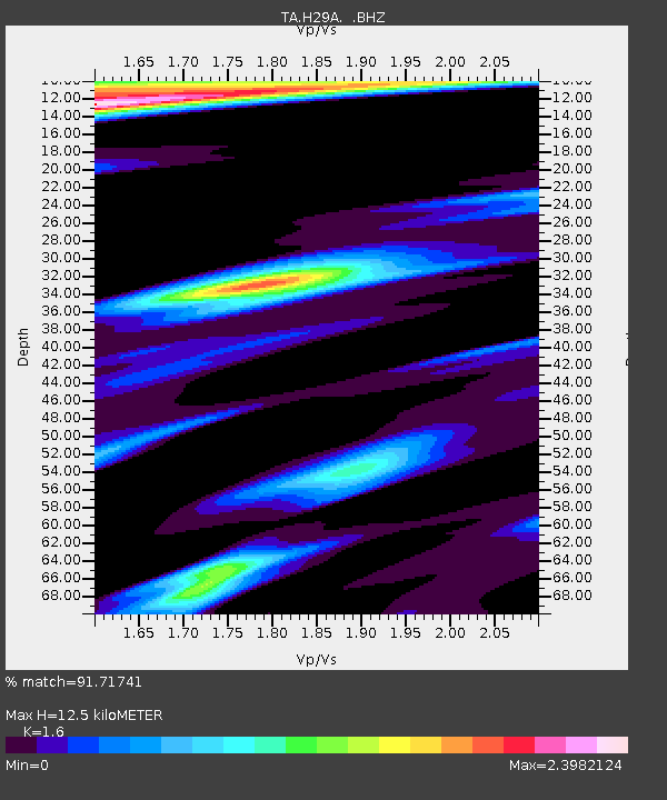
H29A Onida, SD, USA - Earthquake Result Viewer

Earthquake location: Off East Coast Of Honshu, Japan
Earthquake latitude/longitude: 37.6/142.6
Earthquake time(UTC): 2011/03/12 (071) 01:47:15 GMT
Earthquake Depth: 20 km
Earthquake Magnitude: 6.2 MB, 6.4 MS, 6.5 MW, 6.5 MW
Earthquake Catalog/Contributor: WHDF/NEIC
Network: TA USArray Transportable Network (new EarthScope stations)
Station: H29A Onida, SD, USA
Lat/Lon: 44.63 N/100.21 W
Elevation: 548 m
Distance: 80.4 deg
Az: 40.124 deg
Baz: 314.202 deg
Ray Param: 0.048276044
Estimated Moho Depth: 12.5 km
Estimated Crust Vp/Vs: 1.60
Assumed Crust Vp: 6.53 km/s
Estimated Crust Vs: 4.082 km/s
Estimated Crust Poisson's Ratio: 0.18
Radial Match: 91.71741 %
Radial Bump: 381
Transverse Match: 77.16406 %
Transverse Bump: 400
SOD ConfigId: 356183
Insert Time: 2011-08-19 08:16:27.916 +0000
GWidth: 2.5
Max Bumps: 400
Tol: 0.001

Signal To Noise

ChannelStoNSTALTA
TA:H29A: :BHZ:20110312T01:58:54.100012Z11.1364381.8699931E-61.6791661E-7
TA:H29A: :BHN:20110312T01:58:54.100012Z1.33031438.8143116E-76.625736E-7
TA:H29A: :BHE:20110312T01:58:54.100012Z2.65046268.314579E-73.137029E-7
Arrivals
Ps1.2 SECOND
PpPs4.8 SECOND
PsPs/PpSs6.0 SECOND