You are here: Home > Network List > TA - USArray Transportable Network (new EarthScope stations) Stations List
> Station Q33A Connelly Farm, Tescott, KS, USA > Earthquake Result Viewer
Q33A Connelly Farm, Tescott, KS, USA - Earthquake Result Viewer
| Earthquake location: |
Off East Coast Of Honshu, Japan |
| Earthquake latitude/longitude: |
37.6/142.6 |
| Earthquake time(UTC): |
2011/03/12 (071) 01:47:15 GMT |
| Earthquake Depth: |
20 km |
| Earthquake Magnitude: |
6.2 MB, 6.4 MS, 6.5 MW, 6.5 MW |
| Earthquake Catalog/Contributor: |
WHDF/NEIC |
|
| Network: |
TA USArray Transportable Network (new EarthScope stations) |
| Station: |
Q33A Connelly Farm, Tescott, KS, USA |
| Lat/Lon: |
39.00 N/97.83 W |
| Elevation: |
422 m |
|
| Distance: |
85.7 deg |
| Az: |
42.846 deg |
| Baz: |
316.115 deg |
| Ray Param: |
0.044591483 |
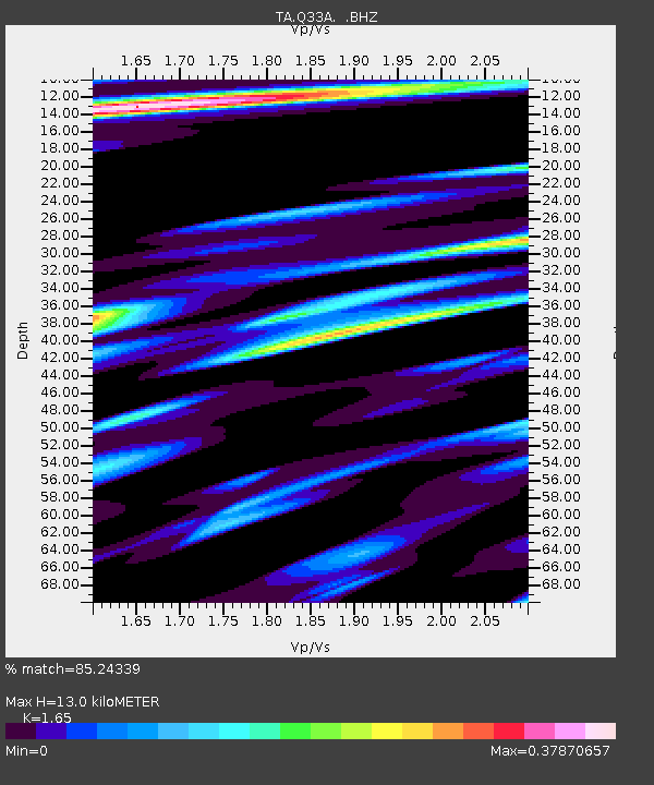
| Estimated Moho Depth: |
13.0 km |
| Estimated Crust Vp/Vs: |
1.65 |
| Assumed Crust Vp: |
6.483 km/s |
| Estimated Crust Vs: |
3.929 km/s |
| Estimated Crust Poisson's Ratio: |
0.21 |
|
| Radial Match: |
85.24339 % |
| Radial Bump: |
400 |
| Transverse Match: |
63.80332 % |
| Transverse Bump: |
400 |
| SOD ConfigId: |
356183 |
| Insert Time: |
2011-08-19 08:22:08.026 +0000 |
| GWidth: |
2.5 |
| Max Bumps: |
400 |
| Tol: |
0.001 |
|

Signal To Noise
| Channel | StoN | STA | LTA |
| TA:Q33A: :BHZ:20110312T01:59:21.124976Z | 5.929658 | 1.5440969E-6 | 2.6040237E-7 |
| TA:Q33A: :BHN:20110312T01:59:21.124976Z | 1.5229774 | 3.7522815E-7 | 2.4637805E-7 |
| TA:Q33A: :BHE:20110312T01:59:21.124976Z | 2.2794163 | 4.394863E-7 | 1.9280651E-7 |
| Arrivals |
| Ps | 1.3 SECOND |
| PpPs | 5.2 SECOND |
| PsPs/PpSs | 6.5 SECOND |


