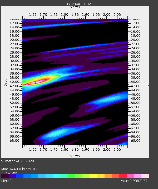
V34A Guthrie, OK, USA - Earthquake Result Viewer
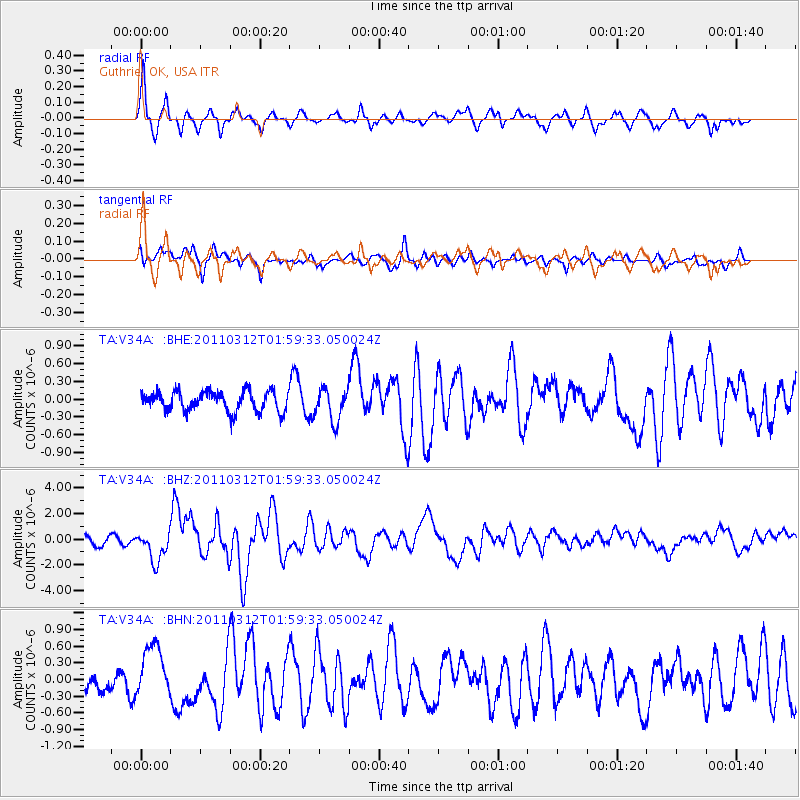
Earthquake location: Off East Coast Of Honshu, Japan
Earthquake latitude/longitude: 37.6/142.6
Earthquake time(UTC): 2011/03/12 (071) 01:47:15 GMT
Earthquake Depth: 20 km
Earthquake Magnitude: 6.2 MB, 6.4 MS, 6.5 MW, 6.5 MW
Earthquake Catalog/Contributor: WHDF/NEIC
Network: TA USArray Transportable Network (new EarthScope stations)
Station: V34A Guthrie, OK, USA
Lat/Lon: 35.83 N/97.52 W
Elevation: 329 m
Distance: 88.1 deg
Az: 44.851 deg
Baz: 316.415 deg
Ray Param: 0.042812917
Estimated Moho Depth: 40.0 km
Estimated Crust Vp/Vs: 1.66
Assumed Crust Vp: 6.426 km/s
Estimated Crust Vs: 3.871 km/s
Estimated Crust Poisson's Ratio: 0.22
Radial Match: 87.69829 %
Radial Bump: 400
Transverse Match: 66.51996 %
Transverse Bump: 400
SOD ConfigId: 356183
Insert Time: 2011-08-19 08:24:42.590 +0000
GWidth: 2.5
Max Bumps: 400
Tol: 0.001

Signal To Noise

ChannelStoNSTALTA
TA:V34A: :BHZ:20110312T01:59:33.050024Z4.47366331.1619478E-62.597307E-7
TA:V34A: :BHN:20110312T01:59:33.050024Z1.59001664.256891E-72.6772622E-7
TA:V34A: :BHE:20110312T01:59:33.050024Z1.64791132.729307E-71.656222E-7
Arrivals
Ps4.2 SECOND
PpPs16 SECOND
PsPs/PpSs20 SECOND