You are here: Home > Network List > TA - USArray Transportable Network (new EarthScope stations) Stations List
> Station 533A Kerrville, TX, USA > Earthquake Result Viewer
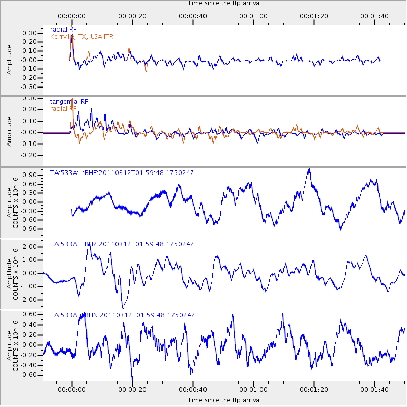
533A Kerrville, TX, USA - Earthquake Result Viewer
*The percent match for this event was below the threshold and hence no stack was calculated.
| Earthquake location: |
Off East Coast Of Honshu, Japan |
| Earthquake latitude/longitude: |
37.6/142.6 |
| Earthquake time(UTC): |
2011/03/12 (071) 01:47:15 GMT |
| Earthquake Depth: |
20 km |
| Earthquake Magnitude: |
6.2 MB, 6.4 MS, 6.5 MW, 6.5 MW |
| Earthquake Catalog/Contributor: |
WHDF/NEIC |
|
| Network: |
TA USArray Transportable Network (new EarthScope stations) |
| Station: |
533A Kerrville, TX, USA |
| Lat/Lon: |
30.07 N/99.04 W |
| Elevation: |
556 m |
|
| Distance: |
91.4 deg |
| Az: |
49.759 deg |
| Baz: |
315.615 deg |
| Ray Param: |
$rayparam |
*The percent match for this event was below the threshold and hence was not used in the summary stack. |
|
| Radial Match: |
75.196556 % |
| Radial Bump: |
400 |
| Transverse Match: |
87.0841 % |
| Transverse Bump: |
388 |
| SOD ConfigId: |
356183 |
| Insert Time: |
2011-08-19 08:25:25.039 +0000 |
| GWidth: |
2.5 |
| Max Bumps: |
400 |
| Tol: |
0.001 |
|
Signal To Noise
| Channel | StoN | STA | LTA |
| TA:533A: :BHZ:20110312T01:59:48.175024Z | 3.1533618 | 8.724906E-7 | 2.7668585E-7 |
| TA:533A: :BHN:20110312T01:59:48.175024Z | 2.6690133 | 3.79941E-7 | 1.4235262E-7 |
| TA:533A: :BHE:20110312T01:59:48.175024Z | 1.8002682 | 3.812842E-7 | 2.11793E-7 |
| Arrivals |
| Ps | |
| PpPs | |
| PsPs/PpSs | |


