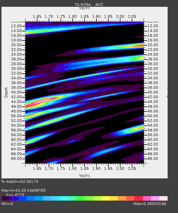
W35A Tecumseh, OK, USA - Earthquake Result Viewer

Earthquake location: Off East Coast Of Honshu, Japan
Earthquake latitude/longitude: 37.6/142.6
Earthquake time(UTC): 2011/03/12 (071) 01:47:15 GMT
Earthquake Depth: 20 km
Earthquake Magnitude: 6.2 MB, 6.4 MS, 6.5 MW, 6.5 MW
Earthquake Catalog/Contributor: WHDF/NEIC
Network: TA USArray Transportable Network (new EarthScope stations)
Station: W35A Tecumseh, OK, USA
Lat/Lon: 35.15 N/96.87 W
Elevation: 322 m
Distance: 89.0 deg
Az: 44.937 deg
Baz: 316.789 deg
Ray Param: 0.04217812
Estimated Moho Depth: 43.25 km
Estimated Crust Vp/Vs: 1.68
Assumed Crust Vp: 6.426 km/s
Estimated Crust Vs: 3.831 km/s
Estimated Crust Poisson's Ratio: 0.22
Radial Match: 82.58175 %
Radial Bump: 400
Transverse Match: 55.272217 %
Transverse Bump: 400
SOD ConfigId: 356183
Insert Time: 2011-08-19 08:43:14.935 +0000
GWidth: 2.5
Max Bumps: 400
Tol: 0.001

Signal To Noise

ChannelStoNSTALTA
TA:W35A: :BHZ:20110312T01:59:37.050024Z5.34816071.0511473E-61.9654371E-7
TA:W35A: :BHN:20110312T01:59:37.050024Z0.732947232.2927681E-73.1281488E-7
TA:W35A: :BHE:20110312T01:59:37.050024Z1.73515672.582018E-71.4880604E-7
Arrivals
Ps4.7 SECOND
PpPs18 SECOND
PsPs/PpSs22 SECOND