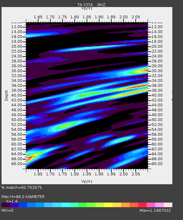
Y37A Hugo, OK, USA - Earthquake Result Viewer

Earthquake location: Off East Coast Of Honshu, Japan
Earthquake latitude/longitude: 37.6/142.6
Earthquake time(UTC): 2011/03/12 (071) 01:47:15 GMT
Earthquake Depth: 20 km
Earthquake Magnitude: 6.2 MB, 6.4 MS, 6.5 MW, 6.5 MW
Earthquake Catalog/Contributor: WHDF/NEIC
Network: TA USArray Transportable Network (new EarthScope stations)
Station: Y37A Hugo, OK, USA
Lat/Lon: 33.98 N/95.62 W
Elevation: 165 m
Distance: 90.5 deg
Az: 44.975 deg
Baz: 317.497 deg
Ray Param: 0.041665405
Estimated Moho Depth: 66.0 km
Estimated Crust Vp/Vs: 1.60
Assumed Crust Vp: 6.245 km/s
Estimated Crust Vs: 3.903 km/s
Estimated Crust Poisson's Ratio: 0.18
Radial Match: 80.782875 %
Radial Bump: 400
Transverse Match: 66.95048 %
Transverse Bump: 400
SOD ConfigId: 356183
Insert Time: 2011-08-19 08:47:24.744 +0000
GWidth: 2.5
Max Bumps: 400
Tol: 0.001

Signal To Noise

ChannelStoNSTALTA
TA:Y37A: :BHZ:20110312T01:59:44.324988Z5.10394439.495768E-71.8604764E-7
TA:Y37A: :BHN:20110312T01:59:44.324988Z1.94306123.761211E-71.9357142E-7
TA:Y37A: :BHE:20110312T01:59:44.324988Z1.70609242.0763386E-71.2170142E-7
Arrivals
Ps6.5 SECOND
PpPs27 SECOND
PsPs/PpSs33 SECOND