You are here: Home > Network List > TA - USArray Transportable Network (new EarthScope stations) Stations List
> Station Q35A Mercer Eighty, Eskridge, KS, USA > Earthquake Result Viewer
Q35A Mercer Eighty, Eskridge, KS, USA - Earthquake Result Viewer
| Earthquake location: |
Off East Coast Of Honshu, Japan |
| Earthquake latitude/longitude: |
37.6/142.6 |
| Earthquake time(UTC): |
2011/03/12 (071) 01:47:15 GMT |
| Earthquake Depth: |
20 km |
| Earthquake Magnitude: |
6.2 MB, 6.4 MS, 6.5 MW, 6.5 MW |
| Earthquake Catalog/Contributor: |
WHDF/NEIC |
|
| Network: |
TA USArray Transportable Network (new EarthScope stations) |
| Station: |
Q35A Mercer Eighty, Eskridge, KS, USA |
| Lat/Lon: |
38.86 N/96.04 W |
| Elevation: |
402 m |
|
| Distance: |
86.7 deg |
| Az: |
41.921 deg |
| Baz: |
317.178 deg |
| Ray Param: |
0.043830704 |
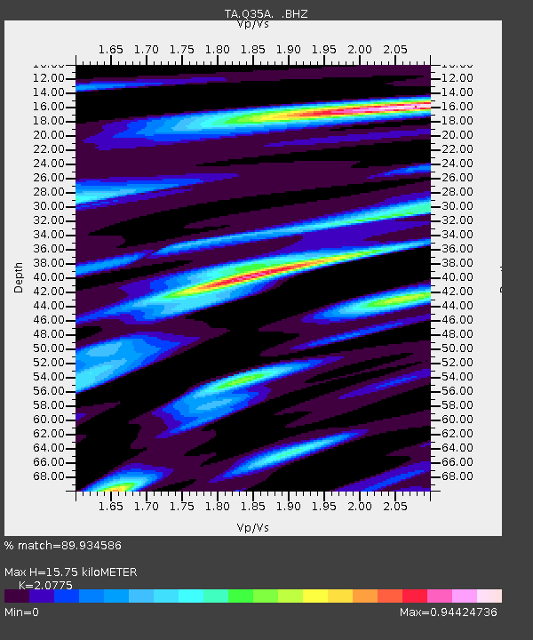
| Estimated Moho Depth: |
15.75 km |
| Estimated Crust Vp/Vs: |
2.08 |
| Assumed Crust Vp: |
6.483 km/s |
| Estimated Crust Vs: |
3.12 km/s |
| Estimated Crust Poisson's Ratio: |
0.35 |
|
| Radial Match: |
89.934586 % |
| Radial Bump: |
400 |
| Transverse Match: |
71.211525 % |
| Transverse Bump: |
400 |
| SOD ConfigId: |
356183 |
| Insert Time: |
2011-08-19 08:50:01.426 +0000 |
| GWidth: |
2.5 |
| Max Bumps: |
400 |
| Tol: |
0.001 |
|

Signal To Noise
| Channel | StoN | STA | LTA |
| TA:Q35A: :BHZ:20110312T01:59:26.324988Z | 9.502668 | 1.644047E-6 | 1.7300898E-7 |
| TA:Q35A: :BHN:20110312T01:59:26.324988Z | 2.7810988 | 6.109279E-7 | 2.196714E-7 |
| TA:Q35A: :BHE:20110312T01:59:26.324988Z | 2.8456273 | 4.0407517E-7 | 1.4199863E-7 |
| Arrivals |
| Ps | 2.7 SECOND |
| PpPs | 7.3 SECOND |
| PsPs/PpSs | 10 SECOND |


