You are here: Home > Network List > TA - USArray Transportable Network (new EarthScope stations) Stations List
> Station Q36A Arnold C. Orvedal, Lecompton, KS, USA > Earthquake Result Viewer
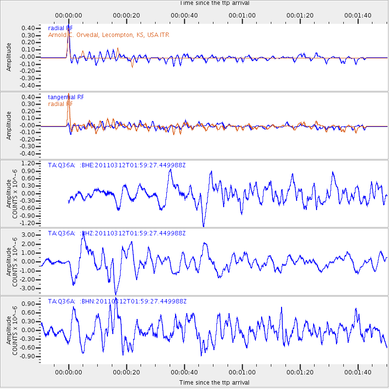
Q36A Arnold C. Orvedal, Lecompton, KS, USA - Earthquake Result Viewer

| Earthquake location: |
Off East Coast Of Honshu, Japan |
| Earthquake latitude/longitude: |
37.6/142.6 |
| Earthquake time(UTC): |
2011/03/12 (071) 01:47:15 GMT |
| Earthquake Depth: |
20 km |
| Earthquake Magnitude: |
6.2 MB, 6.4 MS, 6.5 MW, 6.5 MW |
| Earthquake Catalog/Contributor: |
WHDF/NEIC |
|
| Network: |
TA USArray Transportable Network (new EarthScope stations) |
| Station: |
Q36A Arnold C. Orvedal, Lecompton, KS, USA |
| Lat/Lon: |
38.96 N/95.46 W |
| Elevation: |
306 m |
|
| Distance: |
86.9 deg |
| Az: |
41.521 deg |
| Baz: |
317.516 deg |
| Ray Param: |
0.043662876 |
| Estimated Moho Depth: |
17.5 km |
| Estimated Crust Vp/Vs: |
1.81 |
| Assumed Crust Vp: |
6.498 km/s |
| Estimated Crust Vs: |
3.595 km/s |
| Estimated Crust Poisson's Ratio: |
0.28 |
|
| Radial Match: |
90.06427 % |
| Radial Bump: |
400 |
| Transverse Match: |
62.08235 % |
| Transverse Bump: |
400 |
| SOD ConfigId: |
356183 |
| Insert Time: |
2011-08-19 08:50:46.379 +0000 |
| GWidth: |
2.5 |
| Max Bumps: |
400 |
| Tol: |
0.001 |
|
Signal To Noise
| Channel | StoN | STA | LTA |
| TA:Q36A: :BHZ:20110312T01:59:27.449988Z | 6.8256116 | 1.4968506E-6 | 2.1929911E-7 |
| TA:Q36A: :BHN:20110312T01:59:27.449988Z | 2.2971518 | 4.7130948E-7 | 2.0517125E-7 |
| TA:Q36A: :BHE:20110312T01:59:27.449988Z | 1.9673365 | 4.113069E-7 | 2.0906788E-7 |
| Arrivals |
| Ps | 2.2 SECOND |
| PpPs | 7.4 SECOND |
| PsPs/PpSs | 9.6 SECOND |


