You are here: Home > Network List > TA - USArray Transportable Network (new EarthScope stations) Stations List
> Station M34A Aspy Farms, Fremont, NE, USA > Earthquake Result Viewer
M34A Aspy Farms, Fremont, NE, USA - Earthquake Result Viewer
| Earthquake location: |
Off East Coast Of Honshu, Japan |
| Earthquake latitude/longitude: |
37.6/142.6 |
| Earthquake time(UTC): |
2011/03/12 (071) 01:47:15 GMT |
| Earthquake Depth: |
20 km |
| Earthquake Magnitude: |
6.2 MB, 6.4 MS, 6.5 MW, 6.5 MW |
| Earthquake Catalog/Contributor: |
WHDF/NEIC |
|
| Network: |
TA USArray Transportable Network (new EarthScope stations) |
| Station: |
M34A Aspy Farms, Fremont, NE, USA |
| Lat/Lon: |
41.50 N/96.58 W |
| Elevation: |
415 m |
|
| Distance: |
84.5 deg |
| Az: |
40.42 deg |
| Baz: |
316.712 deg |
| Ray Param: |
0.045419198 |
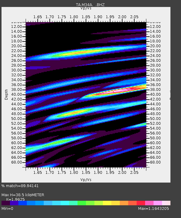
| Estimated Moho Depth: |
38.5 km |
| Estimated Crust Vp/Vs: |
1.96 |
| Assumed Crust Vp: |
6.498 km/s |
| Estimated Crust Vs: |
3.311 km/s |
| Estimated Crust Poisson's Ratio: |
0.32 |
|
| Radial Match: |
89.94141 % |
| Radial Bump: |
400 |
| Transverse Match: |
68.149216 % |
| Transverse Bump: |
400 |
| SOD ConfigId: |
356183 |
| Insert Time: |
2011-08-19 08:54:42.026 +0000 |
| GWidth: |
2.5 |
| Max Bumps: |
400 |
| Tol: |
0.001 |
|

Signal To Noise
| Channel | StoN | STA | LTA |
| TA:M34A: :BHZ:20110312T01:59:15.350012Z | 7.800508 | 1.8170182E-6 | 2.3293588E-7 |
| TA:M34A: :BHN:20110312T01:59:15.350012Z | 3.0432355 | 7.311599E-7 | 2.402574E-7 |
| TA:M34A: :BHE:20110312T01:59:15.350012Z | 1.6258785 | 4.9666255E-7 | 3.0547335E-7 |
| Arrivals |
| Ps | 5.8 SECOND |
| PpPs | 17 SECOND |
| PsPs/PpSs | 23 SECOND |


