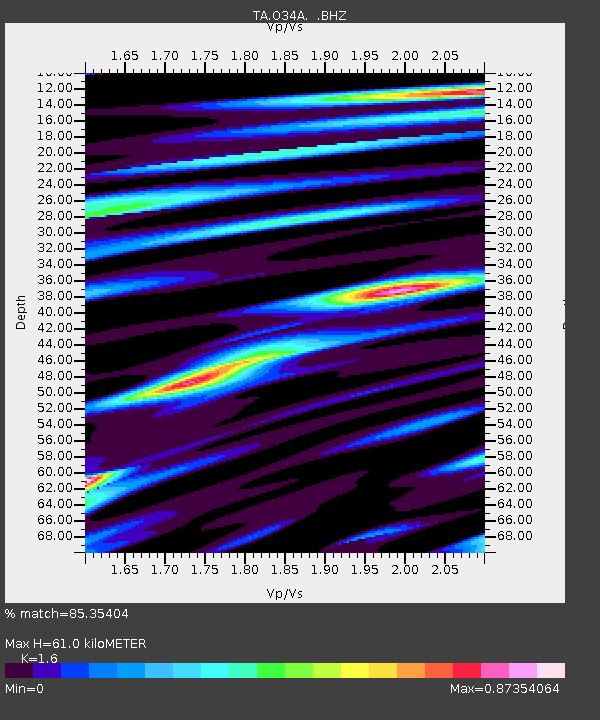
O34A Beatrice, NE, USA - Earthquake Result Viewer
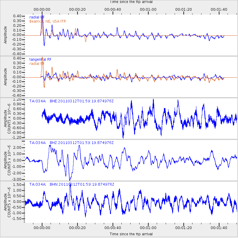
Earthquake location: Off East Coast Of Honshu, Japan
Earthquake latitude/longitude: 37.6/142.6
Earthquake time(UTC): 2011/03/12 (071) 01:47:15 GMT
Earthquake Depth: 20 km
Earthquake Magnitude: 6.2 MB, 6.4 MS, 6.5 MW, 6.5 MW
Earthquake Catalog/Contributor: WHDF/NEIC
Network: TA USArray Transportable Network (new EarthScope stations)
Station: O34A Beatrice, NE, USA
Lat/Lon: 40.18 N/96.69 W
Elevation: 409 m
Distance: 85.4 deg
Az: 41.388 deg
Baz: 316.725 deg
Ray Param: 0.044770975
Estimated Moho Depth: 61.0 km
Estimated Crust Vp/Vs: 1.60
Assumed Crust Vp: 6.498 km/s
Estimated Crust Vs: 4.061 km/s
Estimated Crust Poisson's Ratio: 0.18
Radial Match: 85.35404 %
Radial Bump: 400
Transverse Match: 71.177605 %
Transverse Bump: 400
SOD ConfigId: 356183
Insert Time: 2011-08-19 08:57:00.325 +0000
GWidth: 2.5
Max Bumps: 400
Tol: 0.001

Signal To Noise

ChannelStoNSTALTA
TA:O34A: :BHZ:20110312T01:59:19.874976Z7.2560011.4208972E-61.9582373E-7
TA:O34A: :BHN:20110312T01:59:19.874976Z2.07216484.3979358E-72.1223872E-7
TA:O34A: :BHE:20110312T01:59:19.874976Z1.79593463.3766506E-71.8801634E-7
Arrivals
Ps5.8 SECOND
PpPs24 SECOND
PsPs/PpSs30 SECOND