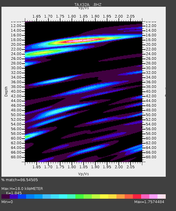
K32A Verdigre, NE, USA - Earthquake Result Viewer

Earthquake location: Off East Coast Of Honshu, Japan
Earthquake latitude/longitude: 37.6/142.6
Earthquake time(UTC): 2011/03/12 (071) 01:47:15 GMT
Earthquake Depth: 20 km
Earthquake Magnitude: 6.2 MB, 6.4 MS, 6.5 MW, 6.5 MW
Earthquake Catalog/Contributor: WHDF/NEIC
Network: TA USArray Transportable Network (new EarthScope stations)
Station: K32A Verdigre, NE, USA
Lat/Lon: 42.66 N/97.97 W
Elevation: 512 m
Distance: 83.0 deg
Az: 40.367 deg
Baz: 315.778 deg
Ray Param: 0.046512645
Estimated Moho Depth: 18.0 km
Estimated Crust Vp/Vs: 1.85
Assumed Crust Vp: 6.498 km/s
Estimated Crust Vs: 3.522 km/s
Estimated Crust Poisson's Ratio: 0.29
Radial Match: 86.54585 %
Radial Bump: 400
Transverse Match: 72.33185 %
Transverse Bump: 400
SOD ConfigId: 356183
Insert Time: 2011-08-19 09:02:18.717 +0000
GWidth: 2.5
Max Bumps: 400
Tol: 0.001

Signal To Noise

ChannelStoNSTALTA
TA:K32A: :BHZ:20110312T01:59:07.449988Z10.5541771.8193181E-61.7237896E-7
TA:K32A: :BHN:20110312T01:59:07.449988Z2.01090436.473333E-73.2191156E-7
TA:K32A: :BHE:20110312T01:59:07.449988Z1.8130064.563822E-72.517268E-7
Arrivals
Ps2.4 SECOND
PpPs7.7 SECOND
PsPs/PpSs10 SECOND