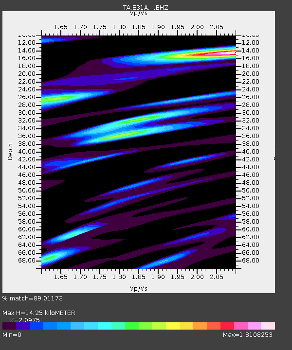
E31A Nome, ND, USA - Earthquake Result Viewer
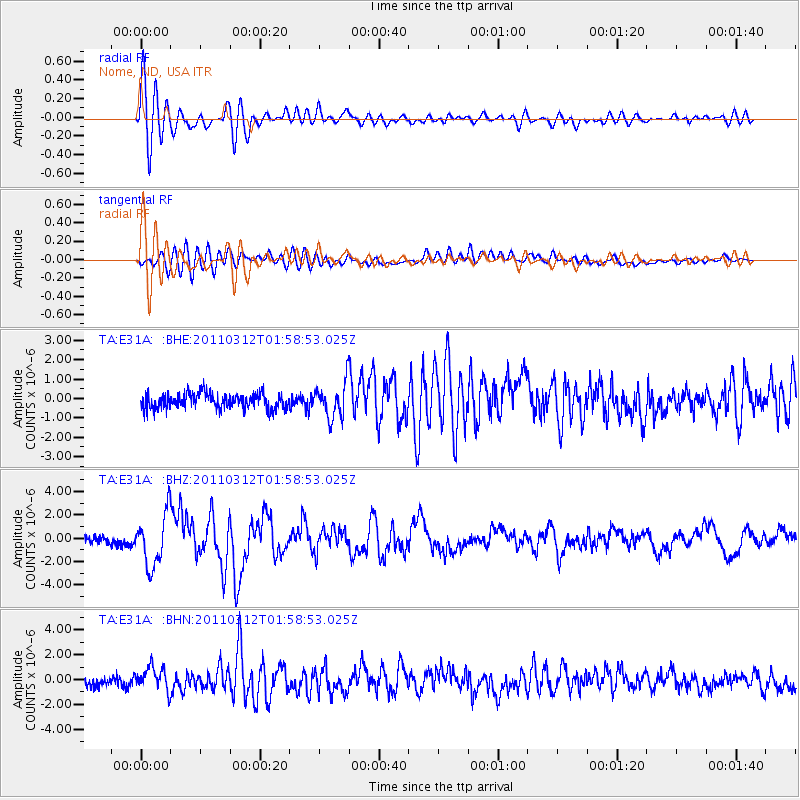
Earthquake location: Off East Coast Of Honshu, Japan
Earthquake latitude/longitude: 37.6/142.6
Earthquake time(UTC): 2011/03/12 (071) 01:47:15 GMT
Earthquake Depth: 20 km
Earthquake Magnitude: 6.2 MB, 6.4 MS, 6.5 MW, 6.5 MW
Earthquake Catalog/Contributor: WHDF/NEIC
Network: TA USArray Transportable Network (new EarthScope stations)
Station: E31A Nome, ND, USA
Lat/Lon: 46.56 N/97.89 W
Elevation: 427 m
Distance: 80.2 deg
Az: 37.566 deg
Baz: 315.427 deg
Ray Param: 0.04841543
Estimated Moho Depth: 14.25 km
Estimated Crust Vp/Vs: 2.10
Assumed Crust Vp: 6.498 km/s
Estimated Crust Vs: 3.098 km/s
Estimated Crust Poisson's Ratio: 0.35
Radial Match: 89.01173 %
Radial Bump: 400
Transverse Match: 63.32823 %
Transverse Bump: 400
SOD ConfigId: 356183
Insert Time: 2011-08-19 09:10:22.115 +0000
GWidth: 2.5
Max Bumps: 400
Tol: 0.001

Signal To Noise

ChannelStoNSTALTA
TA:E31A: :BHZ:20110312T01:58:53.025Z6.6509452.2133863E-63.3279275E-7
TA:E31A: :BHN:20110312T01:58:53.025Z2.30737669.78527E-74.240864E-7
TA:E31A: :BHE:20110312T01:58:53.025Z2.30749829.0438766E-73.919343E-7
Arrivals
Ps2.5 SECOND
PpPs6.6 SECOND
PsPs/PpSs9.1 SECOND