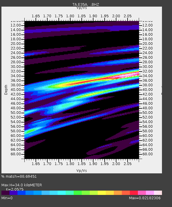
E35A Pequot Lakes, MN, USA - Earthquake Result Viewer
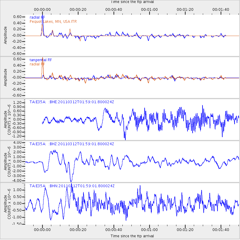
Earthquake location: Off East Coast Of Honshu, Japan
Earthquake latitude/longitude: 37.6/142.6
Earthquake time(UTC): 2011/03/12 (071) 01:47:15 GMT
Earthquake Depth: 20 km
Earthquake Magnitude: 6.2 MB, 6.4 MS, 6.5 MW, 6.5 MW
Earthquake Catalog/Contributor: WHDF/NEIC
Network: TA USArray Transportable Network (new EarthScope stations)
Station: E35A Pequot Lakes, MN, USA
Lat/Lon: 46.56 N/94.40 W
Elevation: 409 m
Distance: 81.9 deg
Az: 35.801 deg
Baz: 317.673 deg
Ray Param: 0.047270402
Estimated Moho Depth: 34.0 km
Estimated Crust Vp/Vs: 2.06
Assumed Crust Vp: 6.419 km/s
Estimated Crust Vs: 3.12 km/s
Estimated Crust Poisson's Ratio: 0.35
Radial Match: 88.69451 %
Radial Bump: 400
Transverse Match: 55.386574 %
Transverse Bump: 400
SOD ConfigId: 356183
Insert Time: 2011-08-19 09:12:26.269 +0000
GWidth: 2.5
Max Bumps: 400
Tol: 0.001

Signal To Noise

ChannelStoNSTALTA
TA:E35A: :BHZ:20110312T01:59:01.800024Z10.9523281.4381833E-61.3131303E-7
TA:E35A: :BHN:20110312T01:59:01.800024Z3.31470377.264136E-72.1914887E-7
TA:E35A: :BHE:20110312T01:59:01.800024Z3.60388684.494608E-71.2471557E-7
Arrivals
Ps5.7 SECOND
PpPs16 SECOND
PsPs/PpSs22 SECOND