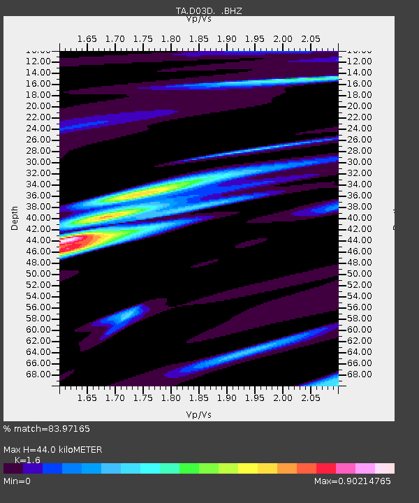
D03D Eldon, WA, USA - Earthquake Result Viewer

Earthquake location: Off East Coast Of Honshu, Japan
Earthquake latitude/longitude: 37.6/142.6
Earthquake time(UTC): 2011/03/12 (071) 01:47:15 GMT
Earthquake Depth: 20 km
Earthquake Magnitude: 6.2 MB, 6.4 MS, 6.5 MW, 6.5 MW
Earthquake Catalog/Contributor: WHDF/NEIC
Network: TA USArray Transportable Network (new EarthScope stations)
Station: D03D Eldon, WA, USA
Lat/Lon: 47.53 N/123.09 W
Elevation: 262 m
Distance: 66.0 deg
Az: 47.705 deg
Baz: 299.876 deg
Ray Param: 0.057882585
Estimated Moho Depth: 44.0 km
Estimated Crust Vp/Vs: 1.60
Assumed Crust Vp: 6.566 km/s
Estimated Crust Vs: 4.104 km/s
Estimated Crust Poisson's Ratio: 0.18
Radial Match: 83.97165 %
Radial Bump: 400
Transverse Match: 83.47273 %
Transverse Bump: 400
SOD ConfigId: 356183
Insert Time: 2011-08-19 09:12:37.312 +0000
GWidth: 2.5
Max Bumps: 400
Tol: 0.001

Signal To Noise

ChannelStoNSTALTA
TA:D03D: :BHZ:20110312T01:57:29.249976Z2.91198252.68959E-69.236285E-7
TA:D03D: :BHN:20110312T01:57:29.249976Z0.70028083.376967E-74.822304E-7
TA:D03D: :BHE:20110312T01:57:29.249976Z1.02747385.969919E-75.810288E-7
Arrivals
Ps4.2 SECOND
PpPs17 SECOND
PsPs/PpSs21 SECOND