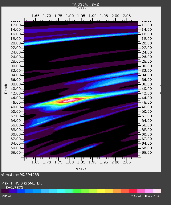
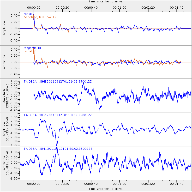
D36A Goodland, MN, USA - Earthquake Result Viewer

Earthquake location: Off East Coast Of Honshu, Japan
Earthquake latitude/longitude: 37.6/142.6
Earthquake time(UTC): 2011/03/12 (071) 01:47:15 GMT
Earthquake Depth: 20 km
Earthquake Magnitude: 6.2 MB, 6.4 MS, 6.5 MW, 6.5 MW
Earthquake Catalog/Contributor: WHDF/NEIC
Network: TA USArray Transportable Network (new EarthScope stations)
Station: D36A Goodland, MN, USA
Lat/Lon: 47.18 N/93.16 W
Elevation: 434 m
Distance: 82.0 deg
Az: 34.743 deg
Baz: 318.427 deg
Ray Param: 0.047194608
Estimated Moho Depth: 45.0 km
Estimated Crust Vp/Vs: 1.79
Assumed Crust Vp: 6.571 km/s
Estimated Crust Vs: 3.676 km/s
Estimated Crust Poisson's Ratio: 0.27
Radial Match: 90.894455 %
Radial Bump: 400
Transverse Match: 62.3052 %
Transverse Bump: 400
SOD ConfigId: 356183
Insert Time: 2011-08-19 09:16:02.814 +0000
GWidth: 2.5
Max Bumps: 400
Tol: 0.001

Signal To Noise

ChannelStoNSTALTA
TA:D36A: :BHZ:20110312T01:59:02.350012Z8.0008041.5792692E-61.9738881E-7
TA:D36A: :BHN:20110312T01:59:02.350012Z2.48286994.956044E-71.996095E-7
TA:D36A: :BHE:20110312T01:59:02.350012Z2.67339785.208188E-71.9481529E-7
Arrivals
Ps5.5 SECOND
PpPs19 SECOND
PsPs/PpSs24 SECOND