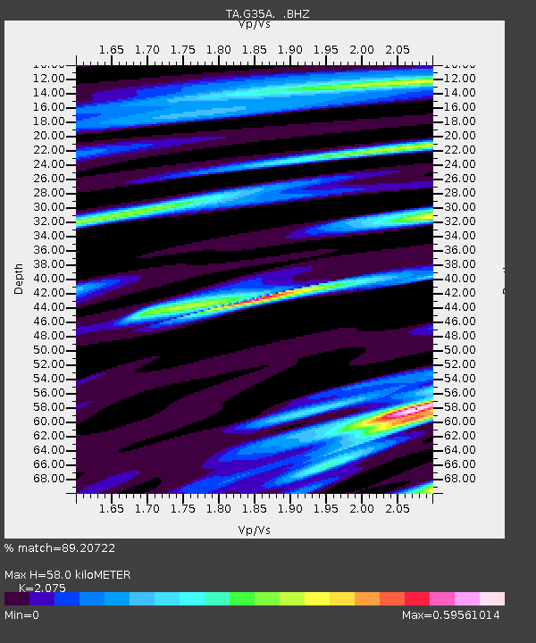
G35A Watkins, MN, USA - Earthquake Result Viewer

Earthquake location: Off East Coast Of Honshu, Japan
Earthquake latitude/longitude: 37.6/142.6
Earthquake time(UTC): 2011/03/12 (071) 01:47:15 GMT
Earthquake Depth: 20 km
Earthquake Magnitude: 6.2 MB, 6.4 MS, 6.5 MW, 6.5 MW
Earthquake Catalog/Contributor: WHDF/NEIC
Network: TA USArray Transportable Network (new EarthScope stations)
Station: G35A Watkins, MN, USA
Lat/Lon: 45.22 N/94.49 W
Elevation: 361 m
Distance: 82.8 deg
Az: 36.751 deg
Baz: 317.742 deg
Ray Param: 0.046608794
Estimated Moho Depth: 58.0 km
Estimated Crust Vp/Vs: 2.08
Assumed Crust Vp: 6.571 km/s
Estimated Crust Vs: 3.167 km/s
Estimated Crust Poisson's Ratio: 0.35
Radial Match: 89.20722 %
Radial Bump: 400
Transverse Match: 65.5318 %
Transverse Bump: 400
SOD ConfigId: 356183
Insert Time: 2011-08-19 09:19:26.787 +0000
GWidth: 2.5
Max Bumps: 400
Tol: 0.001

Signal To Noise

ChannelStoNSTALTA
TA:G35A: :BHZ:20110312T01:59:06.749976Z6.49566461.6822979E-62.589878E-7
TA:G35A: :BHN:20110312T01:59:06.749976Z2.81404735.515441E-71.9599672E-7
TA:G35A: :BHE:20110312T01:59:06.749976Z1.93056443.732368E-71.933304E-7
Arrivals
Ps9.7 SECOND
PpPs27 SECOND
PsPs/PpSs36 SECOND