You are here: Home > Network List > TA - USArray Transportable Network (new EarthScope stations) Stations List
> Station C38A Sawbill Landing (USFS), Superior Nat. Forest, MN, > Earthquake Result Viewer
C38A Sawbill Landing (USFS), Superior Nat. Forest, MN, - Earthquake Result Viewer
| Earthquake location: |
Off East Coast Of Honshu, Japan |
| Earthquake latitude/longitude: |
37.6/142.6 |
| Earthquake time(UTC): |
2011/03/12 (071) 01:47:15 GMT |
| Earthquake Depth: |
20 km |
| Earthquake Magnitude: |
6.2 MB, 6.4 MS, 6.5 MW, 6.5 MW |
| Earthquake Catalog/Contributor: |
WHDF/NEIC |
|
| Network: |
TA USArray Transportable Network (new EarthScope stations) |
| Station: |
C38A Sawbill Landing (USFS), Superior Nat. Forest, MN, |
| Lat/Lon: |
47.72 N/91.27 W |
| Elevation: |
498 m |
|
| Distance: |
82.4 deg |
| Az: |
33.407 deg |
| Baz: |
319.634 deg |
| Ray Param: |
0.046893533 |
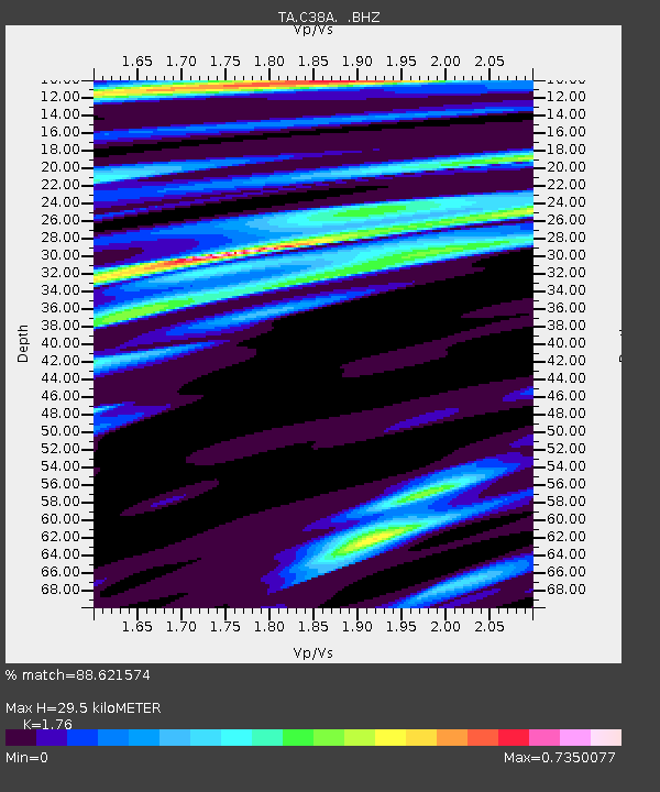
| Estimated Moho Depth: |
29.5 km |
| Estimated Crust Vp/Vs: |
1.76 |
| Assumed Crust Vp: |
6.467 km/s |
| Estimated Crust Vs: |
3.674 km/s |
| Estimated Crust Poisson's Ratio: |
0.26 |
|
| Radial Match: |
88.621574 % |
| Radial Bump: |
400 |
| Transverse Match: |
73.38463 % |
| Transverse Bump: |
400 |
| SOD ConfigId: |
356183 |
| Insert Time: |
2011-08-19 09:21:18.849 +0000 |
| GWidth: |
2.5 |
| Max Bumps: |
400 |
| Tol: |
0.001 |
|
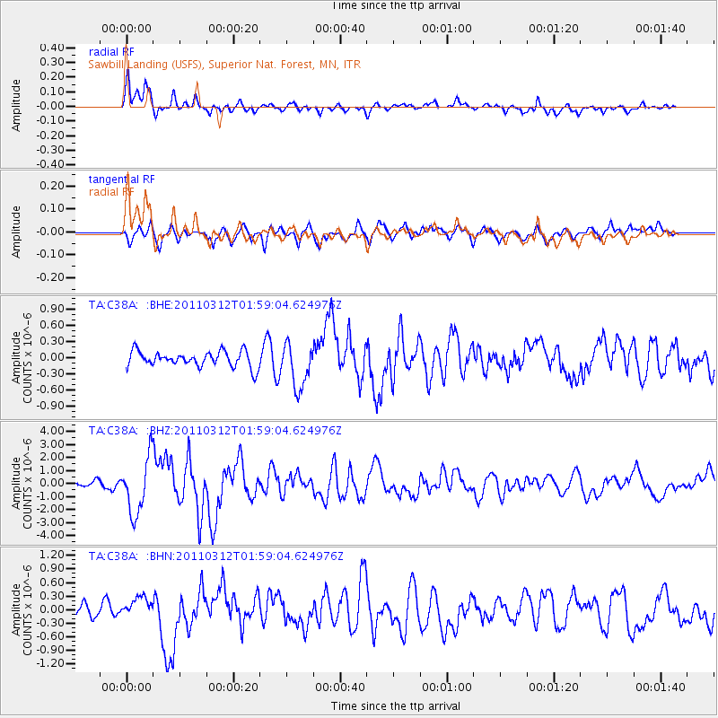
Signal To Noise
| Channel | StoN | STA | LTA |
| TA:C38A: :BHZ:20110312T01:59:04.624976Z | 13.546344 | 2.1503154E-6 | 1.5873769E-7 |
| TA:C38A: :BHN:20110312T01:59:04.624976Z | 1.3157071 | 2.2316112E-7 | 1.6961307E-7 |
| TA:C38A: :BHE:20110312T01:59:04.624976Z | 2.8737738 | 4.1516222E-7 | 1.4446586E-7 |
| Arrivals |
| Ps | 3.6 SECOND |
| PpPs | 12 SECOND |
| PsPs/PpSs | 16 SECOND |


