You are here: Home > Network List > TA - USArray Transportable Network (new EarthScope stations) Stations List
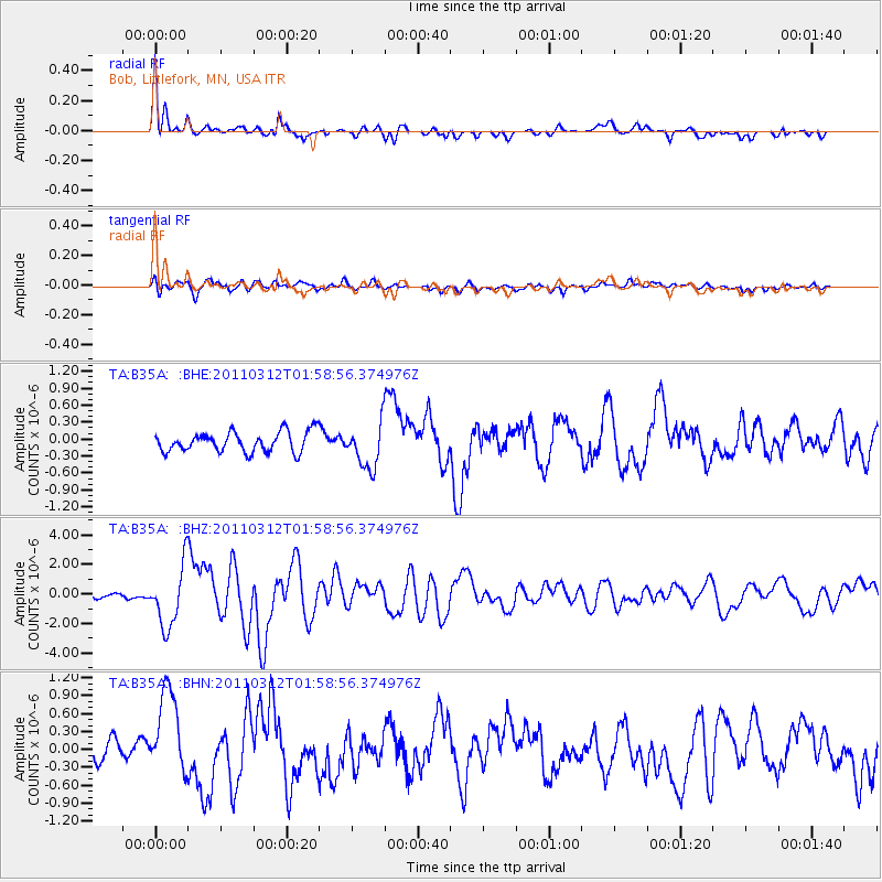
> Station B35A Bob, Littlefork, MN, USA > Earthquake Result Viewer
B35A Bob, Littlefork, MN, USA - Earthquake Result Viewer
| Earthquake location: |
Off East Coast Of Honshu, Japan |
| Earthquake latitude/longitude: |
37.6/142.6 |
| Earthquake time(UTC): |
2011/03/12 (071) 01:47:15 GMT |
| Earthquake Depth: |
20 km |
| Earthquake Magnitude: |
6.2 MB, 6.4 MS, 6.5 MW, 6.5 MW |
| Earthquake Catalog/Contributor: |
WHDF/NEIC |
|
| Network: |
TA USArray Transportable Network (new EarthScope stations) |
| Station: |
B35A Bob, Littlefork, MN, USA |
| Lat/Lon: |
48.36 N/93.73 W |
| Elevation: |
358 m |
|
| Distance: |
80.8 deg |
| Az: |
34.23 deg |
| Baz: |
317.935 deg |
| Ray Param: |
0.0479899 |
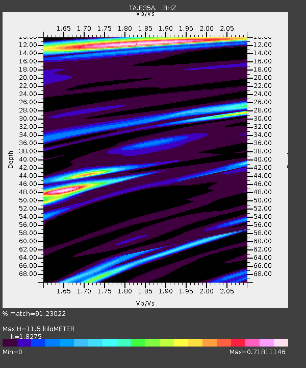
| Estimated Moho Depth: |
11.5 km |
| Estimated Crust Vp/Vs: |
1.83 |
| Assumed Crust Vp: |
6.419 km/s |
| Estimated Crust Vs: |
3.513 km/s |
| Estimated Crust Poisson's Ratio: |
0.29 |
|
| Radial Match: |
91.23022 % |
| Radial Bump: |
400 |
| Transverse Match: |
52.121185 % |
| Transverse Bump: |
400 |
| SOD ConfigId: |
356183 |
| Insert Time: |
2011-08-19 09:27:23.798 +0000 |
| GWidth: |
2.5 |
| Max Bumps: |
400 |
| Tol: |
0.001 |
|
Signal To Noise
| Channel | StoN | STA | LTA |
| TA:B35A: :BHZ:20110312T01:58:56.374976Z | 12.004202 | 2.0497528E-6 | 1.7075293E-7 |
| TA:B35A: :BHN:20110312T01:58:56.374976Z | 3.0258317 | 7.5255446E-7 | 2.4870997E-7 |
| TA:B35A: :BHE:20110312T01:58:56.374976Z | 2.239381 | 3.9896153E-7 | 1.7815705E-7 |
| Arrivals |
| Ps | 1.5 SECOND |
| PpPs | 4.9 SECOND |
| PsPs/PpSs | 6.5 SECOND |


