You are here: Home > Network List > TA - USArray Transportable Network (new EarthScope stations) Stations List
> Station M36A Felix, Anita, IA, USA > Earthquake Result Viewer
M36A Felix, Anita, IA, USA - Earthquake Result Viewer
| Earthquake location: |
Off East Coast Of Honshu, Japan |
| Earthquake latitude/longitude: |
37.6/142.6 |
| Earthquake time(UTC): |
2011/03/12 (071) 01:47:15 GMT |
| Earthquake Depth: |
20 km |
| Earthquake Magnitude: |
6.2 MB, 6.4 MS, 6.5 MW, 6.5 MW |
| Earthquake Catalog/Contributor: |
WHDF/NEIC |
|
| Network: |
TA USArray Transportable Network (new EarthScope stations) |
| Station: |
M36A Felix, Anita, IA, USA |
| Lat/Lon: |
41.45 N/94.80 W |
| Elevation: |
430 m |
|
| Distance: |
85.4 deg |
| Az: |
39.466 deg |
| Baz: |
317.803 deg |
| Ray Param: |
0.044740874 |
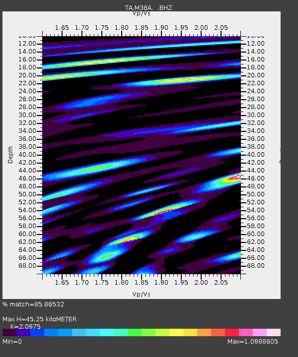
| Estimated Moho Depth: |
45.25 km |
| Estimated Crust Vp/Vs: |
2.10 |
| Assumed Crust Vp: |
6.498 km/s |
| Estimated Crust Vs: |
3.098 km/s |
| Estimated Crust Poisson's Ratio: |
0.35 |
|
| Radial Match: |
85.86532 % |
| Radial Bump: |
400 |
| Transverse Match: |
66.49136 % |
| Transverse Bump: |
400 |
| SOD ConfigId: |
356183 |
| Insert Time: |
2011-08-19 09:31:07.483 +0000 |
| GWidth: |
2.5 |
| Max Bumps: |
400 |
| Tol: |
0.001 |
|
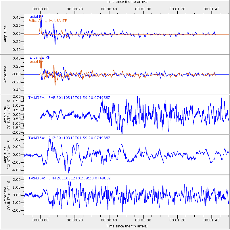
Signal To Noise
| Channel | StoN | STA | LTA |
| TA:M36A: :BHZ:20110312T01:59:20.074988Z | 8.62451 | 1.5555696E-6 | 1.8036614E-7 |
| TA:M36A: :BHN:20110312T01:59:20.074988Z | 1.8258307 | 4.455893E-7 | 2.4404744E-7 |
| TA:M36A: :BHE:20110312T01:59:20.074988Z | 1.5275958 | 3.8854142E-7 | 2.5434832E-7 |
| Arrivals |
| Ps | 7.8 SECOND |
| PpPs | 21 SECOND |
| PsPs/PpSs | 29 SECOND |


