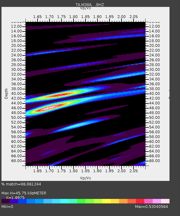
M38A Pleasantville, IA, USA - Earthquake Result Viewer

Earthquake location: Off East Coast Of Honshu, Japan
Earthquake latitude/longitude: 37.6/142.6
Earthquake time(UTC): 2011/03/12 (071) 01:47:15 GMT
Earthquake Depth: 20 km
Earthquake Magnitude: 6.2 MB, 6.4 MS, 6.5 MW, 6.5 MW
Earthquake Catalog/Contributor: WHDF/NEIC
Network: TA USArray Transportable Network (new EarthScope stations)
Station: M38A Pleasantville, IA, USA
Lat/Lon: 41.42 N/93.20 W
Elevation: 258 m
Distance: 86.3 deg
Az: 38.587 deg
Baz: 318.798 deg
Ray Param: 0.04414966
Estimated Moho Depth: 45.75 km
Estimated Crust Vp/Vs: 1.70
Assumed Crust Vp: 6.498 km/s
Estimated Crust Vs: 3.828 km/s
Estimated Crust Poisson's Ratio: 0.23
Radial Match: 86.861244 %
Radial Bump: 400
Transverse Match: 66.15377 %
Transverse Bump: 400
SOD ConfigId: 356183
Insert Time: 2011-08-19 09:32:58.487 +0000
GWidth: 2.5
Max Bumps: 400
Tol: 0.001

Signal To Noise

ChannelStoNSTALTA
TA:M38A: :BHZ:20110312T01:59:24.199988Z6.02531861.4981949E-62.486499E-7
TA:M38A: :BHN:20110312T01:59:24.199988Z1.7395114.2474898E-72.4417724E-7
TA:M38A: :BHE:20110312T01:59:24.199988Z1.31540572.9614225E-72.2513377E-7
Arrivals
Ps5.0 SECOND
PpPs19 SECOND
PsPs/PpSs24 SECOND