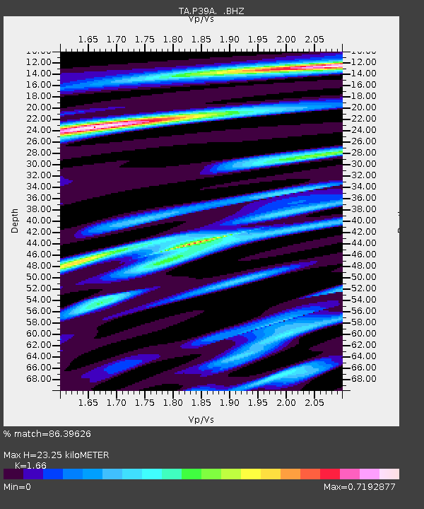
P39A Salisbury, MO, USA - Earthquake Result Viewer
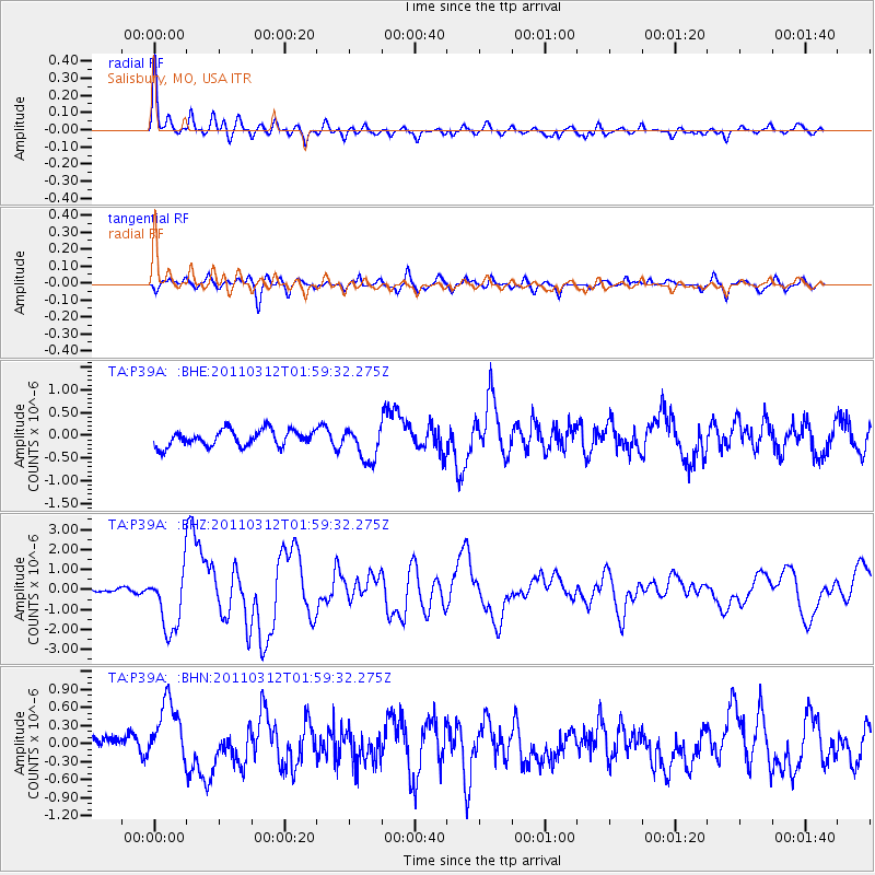
Earthquake location: Off East Coast Of Honshu, Japan
Earthquake latitude/longitude: 37.6/142.6
Earthquake time(UTC): 2011/03/12 (071) 01:47:15 GMT
Earthquake Depth: 20 km
Earthquake Magnitude: 6.2 MB, 6.4 MS, 6.5 MW, 6.5 MW
Earthquake Catalog/Contributor: WHDF/NEIC
Network: TA USArray Transportable Network (new EarthScope stations)
Station: P39A Salisbury, MO, USA
Lat/Lon: 39.49 N/92.75 W
Elevation: 232 m
Distance: 88.0 deg
Az: 39.599 deg
Baz: 319.135 deg
Ray Param: 0.042930715
Estimated Moho Depth: 23.25 km
Estimated Crust Vp/Vs: 1.66
Assumed Crust Vp: 6.498 km/s
Estimated Crust Vs: 3.914 km/s
Estimated Crust Poisson's Ratio: 0.22
Radial Match: 86.39626 %
Radial Bump: 400
Transverse Match: 71.17921 %
Transverse Bump: 400
SOD ConfigId: 356183
Insert Time: 2011-08-19 09:36:20.798 +0000
GWidth: 2.5
Max Bumps: 400
Tol: 0.001

Signal To Noise

ChannelStoNSTALTA
TA:P39A: :BHZ:20110312T01:59:32.275Z13.0449571.5358902E-61.1773823E-7
TA:P39A: :BHN:20110312T01:59:32.275Z3.1974275.1556526E-71.6124379E-7
TA:P39A: :BHE:20110312T01:59:32.275Z2.06378633.6700257E-71.7782975E-7
Arrivals
Ps2.4 SECOND
PpPs9.3 SECOND
PsPs/PpSs12 SECOND