You are here: Home > Network List > TA - USArray Transportable Network (new EarthScope stations) Stations List
> Station R39A Chumby, Stover, MO, USA > Earthquake Result Viewer
R39A Chumby, Stover, MO, USA - Earthquake Result Viewer
| Earthquake location: |
Off East Coast Of Honshu, Japan |
| Earthquake latitude/longitude: |
37.6/142.6 |
| Earthquake time(UTC): |
2011/03/12 (071) 01:47:15 GMT |
| Earthquake Depth: |
20 km |
| Earthquake Magnitude: |
6.2 MB, 6.4 MS, 6.5 MW, 6.5 MW |
| Earthquake Catalog/Contributor: |
WHDF/NEIC |
|
| Network: |
TA USArray Transportable Network (new EarthScope stations) |
| Station: |
R39A Chumby, Stover, MO, USA |
| Lat/Lon: |
38.31 N/93.04 W |
| Elevation: |
290 m |
|
| Distance: |
88.7 deg |
| Az: |
40.535 deg |
| Baz: |
318.985 deg |
| Ray Param: |
0.042379785 |
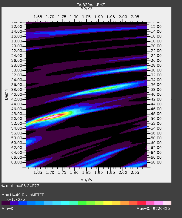
| Estimated Moho Depth: |
49.0 km |
| Estimated Crust Vp/Vs: |
1.71 |
| Assumed Crust Vp: |
6.498 km/s |
| Estimated Crust Vs: |
3.805 km/s |
| Estimated Crust Poisson's Ratio: |
0.24 |
|
| Radial Match: |
86.34877 % |
| Radial Bump: |
318 |
| Transverse Match: |
66.189095 % |
| Transverse Bump: |
400 |
| SOD ConfigId: |
356183 |
| Insert Time: |
2011-08-19 09:38:39.822 +0000 |
| GWidth: |
2.5 |
| Max Bumps: |
400 |
| Tol: |
0.001 |
|

Signal To Noise
| Channel | StoN | STA | LTA |
| TA:R39A: :BHZ:20110312T01:59:35.775Z | 5.1269426 | 1.166172E-6 | 2.2745952E-7 |
| TA:R39A: :BHN:20110312T01:59:35.775Z | 1.7737963 | 2.7432722E-7 | 1.5465542E-7 |
| TA:R39A: :BHE:20110312T01:59:35.775Z | 1.8767303 | 2.9793648E-7 | 1.5875295E-7 |
| Arrivals |
| Ps | 5.5 SECOND |
| PpPs | 20 SECOND |
| PsPs/PpSs | 25 SECOND |


