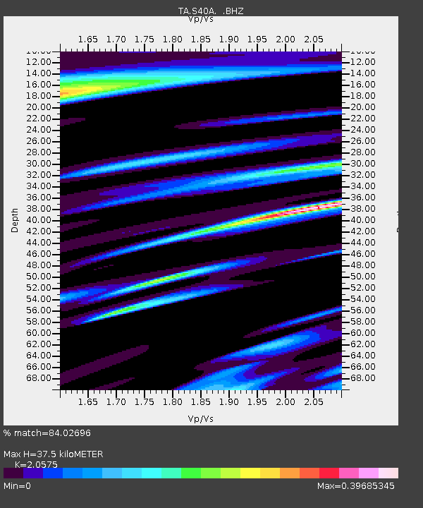
S40A Lebanon, MO, USA - Earthquake Result Viewer
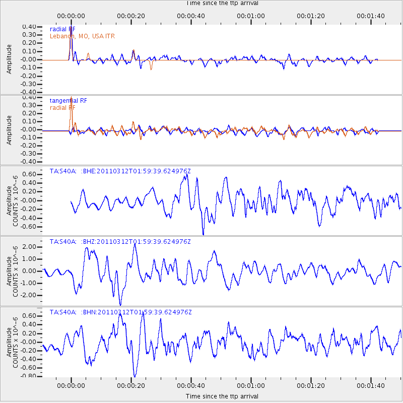
Earthquake location: Off East Coast Of Honshu, Japan
Earthquake latitude/longitude: 37.6/142.6
Earthquake time(UTC): 2011/03/12 (071) 01:47:15 GMT
Earthquake Depth: 20 km
Earthquake Magnitude: 6.2 MB, 6.4 MS, 6.5 MW, 6.5 MW
Earthquake Catalog/Contributor: WHDF/NEIC
Network: TA USArray Transportable Network (new EarthScope stations)
Station: S40A Lebanon, MO, USA
Lat/Lon: 37.60 N/92.50 W
Elevation: 336 m
Distance: 89.5 deg
Az: 40.681 deg
Baz: 319.316 deg
Ray Param: 0.041781142
Estimated Moho Depth: 37.5 km
Estimated Crust Vp/Vs: 2.06
Assumed Crust Vp: 6.53 km/s
Estimated Crust Vs: 3.174 km/s
Estimated Crust Poisson's Ratio: 0.35
Radial Match: 84.02696 %
Radial Bump: 400
Transverse Match: 63.80839 %
Transverse Bump: 400
SOD ConfigId: 356183
Insert Time: 2011-08-19 09:40:23.516 +0000
GWidth: 2.5
Max Bumps: 400
Tol: 0.001

Signal To Noise

ChannelStoNSTALTA
TA:S40A: :BHZ:20110312T01:59:39.624976Z5.86058241.0765667E-61.836962E-7
TA:S40A: :BHN:20110312T01:59:39.624976Z1.28454242.0920248E-71.6286148E-7
TA:S40A: :BHE:20110312T01:59:39.624976Z1.75846241.8761112E-71.06690436E-7
Arrivals
Ps6.2 SECOND
PpPs17 SECOND
PsPs/PpSs23 SECOND