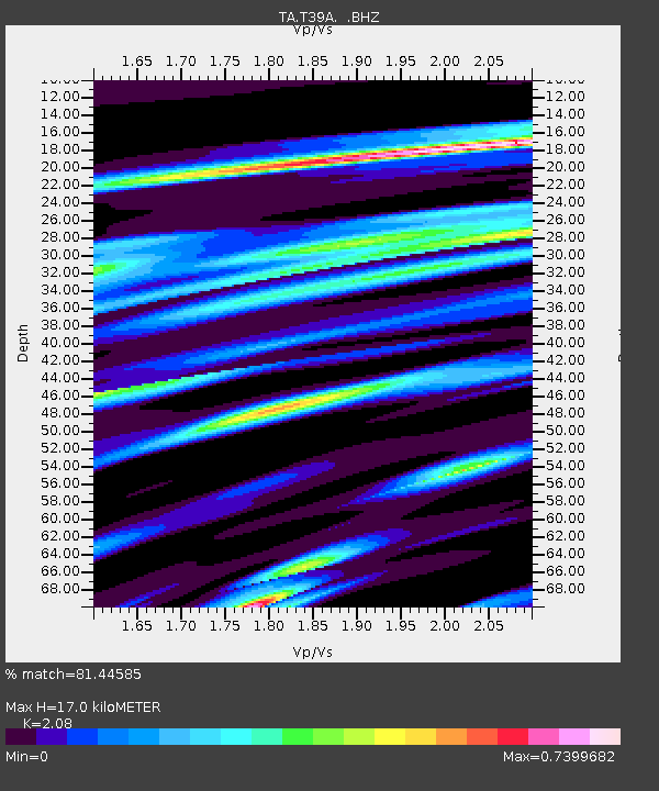
T39A Clever, MO, USA - Earthquake Result Viewer
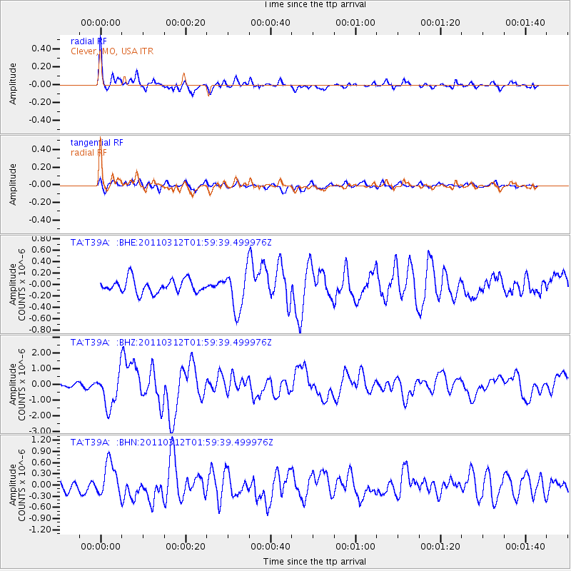
Earthquake location: Off East Coast Of Honshu, Japan
Earthquake latitude/longitude: 37.6/142.6
Earthquake time(UTC): 2011/03/12 (071) 01:47:15 GMT
Earthquake Depth: 20 km
Earthquake Magnitude: 6.2 MB, 6.4 MS, 6.5 MW, 6.5 MW
Earthquake Catalog/Contributor: WHDF/NEIC
Network: TA USArray Transportable Network (new EarthScope stations)
Station: T39A Clever, MO, USA
Lat/Lon: 37.02 N/93.38 W
Elevation: 366 m
Distance: 89.5 deg
Az: 41.584 deg
Baz: 318.795 deg
Ray Param: 0.041798923
Estimated Moho Depth: 17.0 km
Estimated Crust Vp/Vs: 2.08
Assumed Crust Vp: 6.53 km/s
Estimated Crust Vs: 3.14 km/s
Estimated Crust Poisson's Ratio: 0.35
Radial Match: 81.44585 %
Radial Bump: 400
Transverse Match: 65.784836 %
Transverse Bump: 400
SOD ConfigId: 356183
Insert Time: 2011-08-19 09:41:33.497 +0000
GWidth: 2.5
Max Bumps: 400
Tol: 0.001

Signal To Noise

ChannelStoNSTALTA
TA:T39A: :BHZ:20110312T01:59:39.499976Z8.9902581.1418811E-61.2701315E-7
TA:T39A: :BHN:20110312T01:59:39.499976Z2.02659064.60403E-72.2718108E-7
TA:T39A: :BHE:20110312T01:59:39.499976Z3.08332373.6373396E-71.1796814E-7
Arrivals
Ps2.9 SECOND
PpPs7.9 SECOND
PsPs/PpSs11 SECOND