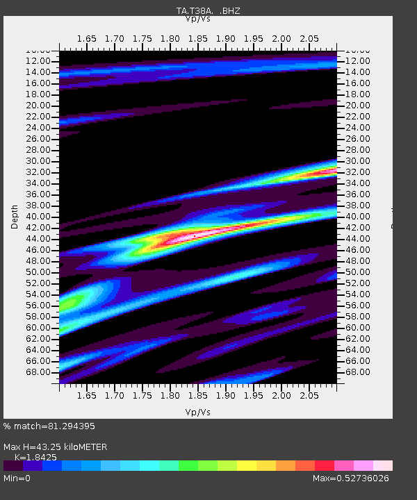
T38A Diamond, MO, USA - Earthquake Result Viewer
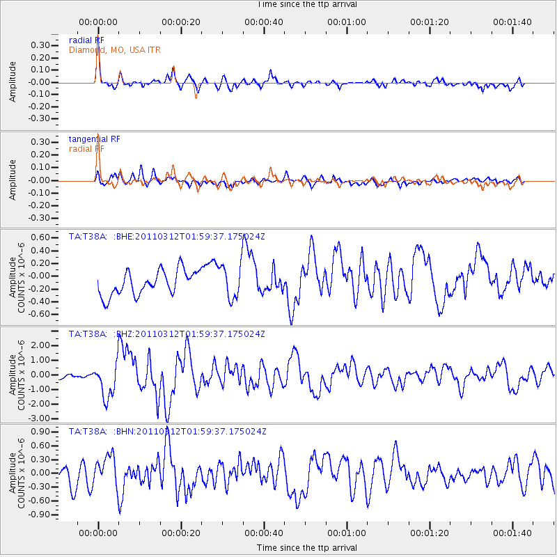
Earthquake location: Off East Coast Of Honshu, Japan
Earthquake latitude/longitude: 37.6/142.6
Earthquake time(UTC): 2011/03/12 (071) 01:47:15 GMT
Earthquake Depth: 20 km
Earthquake Magnitude: 6.2 MB, 6.4 MS, 6.5 MW, 6.5 MW
Earthquake Catalog/Contributor: WHDF/NEIC
Network: TA USArray Transportable Network (new EarthScope stations)
Station: T38A Diamond, MO, USA
Lat/Lon: 37.04 N/94.29 W
Elevation: 349 m
Distance: 89.0 deg
Az: 42.126 deg
Baz: 318.253 deg
Ray Param: 0.04215873
Estimated Moho Depth: 43.25 km
Estimated Crust Vp/Vs: 1.84
Assumed Crust Vp: 6.53 km/s
Estimated Crust Vs: 3.544 km/s
Estimated Crust Poisson's Ratio: 0.29
Radial Match: 81.294395 %
Radial Bump: 370
Transverse Match: 55.524277 %
Transverse Bump: 400
SOD ConfigId: 356183
Insert Time: 2011-08-19 09:42:45.292 +0000
GWidth: 2.5
Max Bumps: 400
Tol: 0.001

Signal To Noise

ChannelStoNSTALTA
TA:T38A: :BHZ:20110312T01:59:37.175024Z8.9399981.2393741E-61.3863247E-7
TA:T38A: :BHN:20110312T01:59:37.175024Z1.70537193.4452438E-72.0202303E-7
TA:T38A: :BHE:20110312T01:59:37.175024Z1.41782072.7177228E-71.9168311E-7
Arrivals
Ps5.7 SECOND
PpPs18 SECOND
PsPs/PpSs24 SECOND