You are here: Home > Network List > US - United States National Seismic Network Stations List
> Station MIAR Mount Ida, Arkansas, USA > Earthquake Result Viewer
MIAR Mount Ida, Arkansas, USA - Earthquake Result Viewer
*The percent match for this event was below the threshold and hence no stack was calculated.
| Earthquake location: |
Off East Coast Of Honshu, Japan |
| Earthquake latitude/longitude: |
37.6/142.6 |
| Earthquake time(UTC): |
2011/03/12 (071) 01:47:15 GMT |
| Earthquake Depth: |
20 km |
| Earthquake Magnitude: |
6.2 MB, 6.4 MS, 6.5 MW, 6.5 MW |
| Earthquake Catalog/Contributor: |
WHDF/NEIC |
|
| Network: |
US United States National Seismic Network |
| Station: |
MIAR Mount Ida, Arkansas, USA |
| Lat/Lon: |
34.55 N/93.58 W |
| Elevation: |
207 m |
|
| Distance: |
91.2 deg |
| Az: |
43.337 deg |
| Baz: |
318.668 deg |
| Ray Param: |
$rayparam |
*The percent match for this event was below the threshold and hence was not used in the summary stack. |
|
| Radial Match: |
74.95494 % |
| Radial Bump: |
400 |
| Transverse Match: |
52.178516 % |
| Transverse Bump: |
400 |
| SOD ConfigId: |
356183 |
| Insert Time: |
2011-08-19 09:52:18.268 +0000 |
| GWidth: |
2.5 |
| Max Bumps: |
400 |
| Tol: |
0.001 |
|
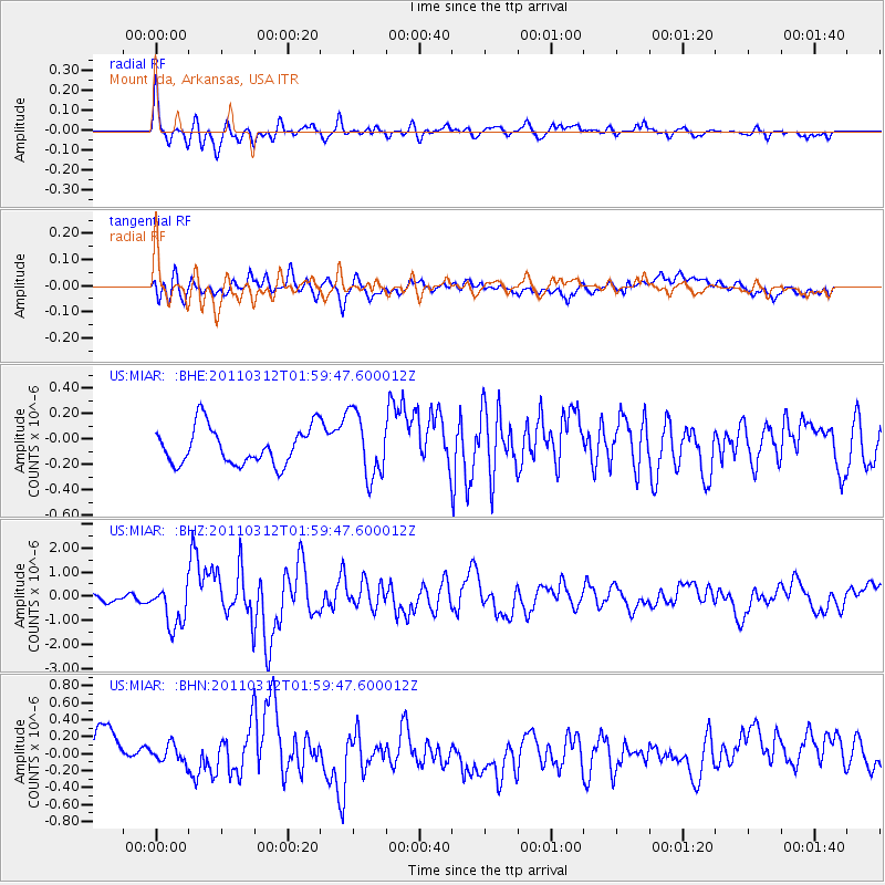
Signal To Noise
| Channel | StoN | STA | LTA |
| US:MIAR: :BHZ:20110312T01:59:47.600012Z | 5.8314023 | 8.994787E-7 | 1.542474E-7 |
| US:MIAR: :BHN:20110312T01:59:47.600012Z | 0.4938479 | 1.0667857E-7 | 2.1601502E-7 |
| US:MIAR: :BHE:20110312T01:59:47.600012Z | 1.7220118 | 2.5202695E-7 | 1.463561E-7 |
| Arrivals |
| Ps | |
| PpPs | |
| PsPs/PpSs | |


