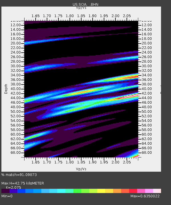
SCIA State Center, Iowa, USA - Earthquake Result Viewer

Earthquake location: Off East Coast Of Honshu, Japan
Earthquake latitude/longitude: 37.6/142.6
Earthquake time(UTC): 2011/03/12 (071) 01:47:15 GMT
Earthquake Depth: 20 km
Earthquake Magnitude: 6.2 MB, 6.4 MS, 6.5 MW, 6.5 MW
Earthquake Catalog/Contributor: WHDF/NEIC
Network: US United States National Seismic Network
Station: SCIA State Center, Iowa, USA
Lat/Lon: 41.91 N/93.22 W
Elevation: 312 m
Distance: 85.9 deg
Az: 38.274 deg
Baz: 318.765 deg
Ray Param: 0.044417087
Estimated Moho Depth: 42.75 km
Estimated Crust Vp/Vs: 2.08
Assumed Crust Vp: 6.498 km/s
Estimated Crust Vs: 3.131 km/s
Estimated Crust Poisson's Ratio: 0.35
Radial Match: 91.09873 %
Radial Bump: 347
Transverse Match: 58.683147 %
Transverse Bump: 400
SOD ConfigId: 356183
Insert Time: 2011-08-19 10:00:35.797 +0000
GWidth: 2.5
Max Bumps: 400
Tol: 0.001

Signal To Noise

ChannelStoNSTALTA
US:SCIA: :BHZ:20110312T01:59:22.324988Z4.7213161.5698213E-63.3249657E-7
US:SCIA: :BHN:20110312T01:59:22.324988Z4.0709987.931017E-71.948175E-7
US:SCIA: :BHE:20110312T01:59:22.324988Z1.84001184.029177E-72.189756E-7
Arrivals
Ps7.2 SECOND
PpPs20 SECOND
PsPs/PpSs27 SECOND