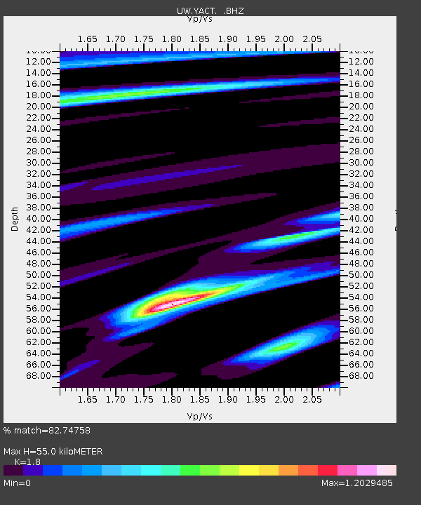
YACT Amboy, WA, USA - Earthquake Result Viewer
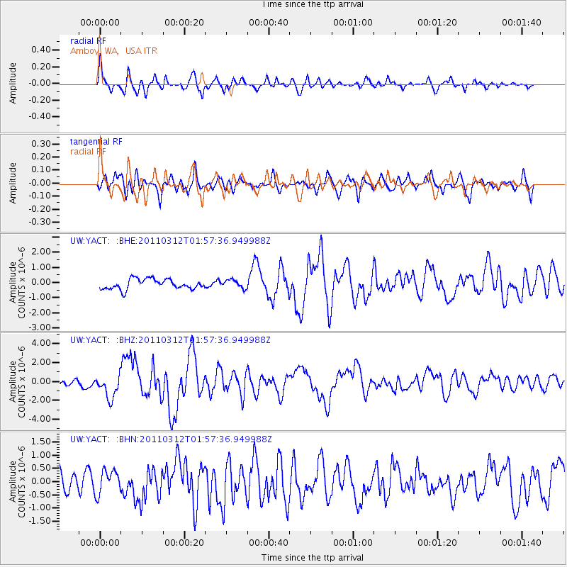
Earthquake location: Off East Coast Of Honshu, Japan
Earthquake latitude/longitude: 37.6/142.6
Earthquake time(UTC): 2011/03/12 (071) 01:47:15 GMT
Earthquake Depth: 20 km
Earthquake Magnitude: 6.2 MB, 6.4 MS, 6.5 MW, 6.5 MW
Earthquake Catalog/Contributor: WHDF/NEIC
Network: UW Pacific Northwest Regional Seismic Network
Station: YACT Amboy, WA, USA
Lat/Lon: 45.93 N/122.42 W
Elevation: 211 m
Distance: 67.2 deg
Az: 48.958 deg
Baz: 300.86 deg
Ray Param: 0.057086382
Estimated Moho Depth: 55.0 km
Estimated Crust Vp/Vs: 1.80
Assumed Crust Vp: 6.566 km/s
Estimated Crust Vs: 3.648 km/s
Estimated Crust Poisson's Ratio: 0.28
Radial Match: 82.74758 %
Radial Bump: 400
Transverse Match: 66.40192 %
Transverse Bump: 400
SOD ConfigId: 356183
Insert Time: 2011-08-19 10:05:19.331 +0000
GWidth: 2.5
Max Bumps: 400
Tol: 0.001

Signal To Noise

ChannelStoNSTALTA
UW:YACT: :BHZ:20110312T01:57:36.949988Z2.77811071.3103938E-64.7168524E-7
UW:YACT: :BHN:20110312T01:57:36.949988Z1.1585454.430815E-73.8244647E-7
UW:YACT: :BHE:20110312T01:57:36.949988Z0.82922622.7602044E-73.3286506E-7
Arrivals
Ps7.0 SECOND
PpPs23 SECOND
PsPs/PpSs29 SECOND