You are here: Home > Network List > NE - New England Seismic Network Stations List
> Station PQI Presque Isle, ME, USA > Earthquake Result Viewer
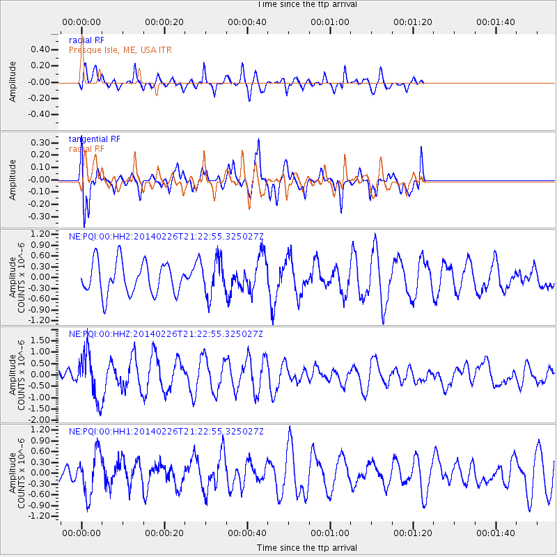
PQI Presque Isle, ME, USA - Earthquake Result Viewer
*The percent match for this event was below the threshold and hence no stack was calculated.
| Earthquake location: |
Fox Islands, Aleutian Islands |
| Earthquake latitude/longitude: |
53.6/-171.8 |
| Earthquake time(UTC): |
2014/02/26 (057) 21:13:40 GMT |
| Earthquake Depth: |
265 km |
| Earthquake Magnitude: |
6.1 MWW, 5.9 MI, 5.9 ML, 6.1 MWC, 6.1 MWB, 6.2 MWC |
| Earthquake Catalog/Contributor: |
NEIC PDE/NEIC COMCAT |
|
| Network: |
NE New England Seismic Network |
| Station: |
PQI Presque Isle, ME, USA |
| Lat/Lon: |
46.67 N/68.02 W |
| Elevation: |
162 m |
|
| Distance: |
61.0 deg |
| Az: |
49.854 deg |
| Baz: |
318.584 deg |
| Ray Param: |
$rayparam |
*The percent match for this event was below the threshold and hence was not used in the summary stack. |
|
| Radial Match: |
63.342026 % |
| Radial Bump: |
341 |
| Transverse Match: |
67.496605 % |
| Transverse Bump: |
400 |
| SOD ConfigId: |
3390531 |
| Insert Time: |
2019-04-10 10:52:45.879 +0000 |
| GWidth: |
2.5 |
| Max Bumps: |
400 |
| Tol: |
0.001 |
|
Signal To Noise
| Channel | StoN | STA | LTA |
| NE:PQI:00:HHZ:20140226T21:22:55.325027Z | 2.0036023 | 1.0107389E-6 | 5.0446084E-7 |
| NE:PQI:00:HH1:20140226T21:22:55.325027Z | 2.0619442 | 6.0140377E-7 | 2.916683E-7 |
| NE:PQI:00:HH2:20140226T21:22:55.325027Z | 1.1465033 | 5.1022806E-7 | 4.450297E-7 |
| Arrivals |
| Ps | |
| PpPs | |
| PsPs/PpSs | |


