You are here: Home > Network List > UW - Pacific Northwest Regional Seismic Network Stations List
> Station UMAT Pilot Rock, OR, USA > Earthquake Result Viewer
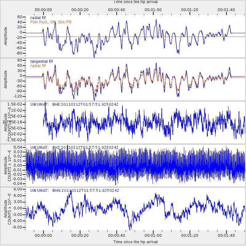
UMAT Pilot Rock, OR, USA - Earthquake Result Viewer
*The percent match for this event was below the threshold and hence no stack was calculated.
| Earthquake location: |
Off East Coast Of Honshu, Japan |
| Earthquake latitude/longitude: |
37.6/142.6 |
| Earthquake time(UTC): |
2011/03/12 (071) 01:47:15 GMT |
| Earthquake Depth: |
20 km |
| Earthquake Magnitude: |
6.2 MB, 6.4 MS, 6.5 MW, 6.5 MW |
| Earthquake Catalog/Contributor: |
WHDF/NEIC |
|
| Network: |
UW Pacific Northwest Regional Seismic Network |
| Station: |
UMAT Pilot Rock, OR, USA |
| Lat/Lon: |
45.29 N/118.96 W |
| Elevation: |
1318 m |
|
| Distance: |
69.6 deg |
| Az: |
48.162 deg |
| Baz: |
303.032 deg |
| Ray Param: |
$rayparam |
*The percent match for this event was below the threshold and hence was not used in the summary stack. |
|
| Radial Match: |
30.032017 % |
| Radial Bump: |
400 |
| Transverse Match: |
30.029095 % |
| Transverse Bump: |
400 |
| SOD ConfigId: |
356183 |
| Insert Time: |
2011-08-19 10:07:52.277 +0000 |
| GWidth: |
2.5 |
| Max Bumps: |
400 |
| Tol: |
0.001 |
|
Signal To Noise
| Channel | StoN | STA | LTA |
| UW:UMAT: :BHZ:20110312T01:57:51.925024Z | 1.0002513 | 1.7310871E-8 | 1.730652E-8 |
| UW:UMAT: :BHN:20110312T01:57:51.925024Z | 1.2878474 | 3.9716647E-6 | 3.0839562E-6 |
| UW:UMAT: :BHE:20110312T01:57:51.925024Z | 0.6896602 | 3.5211245E-9 | 5.105593E-9 |
| Arrivals |
| Ps | |
| PpPs | |
| PsPs/PpSs | |


