You are here: Home > Network List > TA - USArray Transportable Network (new EarthScope stations) Stations List
> Station A32A Rocking H Ranch, Lancaster, MN, USA > Earthquake Result Viewer
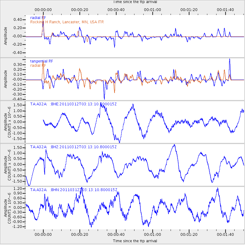
A32A Rocking H Ranch, Lancaster, MN, USA - Earthquake Result Viewer
*The percent match for this event was below the threshold and hence no stack was calculated.
| Earthquake location: |
Near East Coast Of Honshu, Japan |
| Earthquake latitude/longitude: |
39.5/142.6 |
| Earthquake time(UTC): |
2011/03/12 (071) 03:01:47 GMT |
| Earthquake Depth: |
20 km |
| Earthquake Magnitude: |
5.8 MB |
| Earthquake Catalog/Contributor: |
WHDF/NEIC |
|
| Network: |
TA USArray Transportable Network (new EarthScope stations) |
| Station: |
A32A Rocking H Ranch, Lancaster, MN, USA |
| Lat/Lon: |
48.92 N/96.49 W |
| Elevation: |
322 m |
|
| Distance: |
77.6 deg |
| Az: |
35.414 deg |
| Baz: |
317.218 deg |
| Ray Param: |
$rayparam |
*The percent match for this event was below the threshold and hence was not used in the summary stack. |
|
| Radial Match: |
67.13021 % |
| Radial Bump: |
400 |
| Transverse Match: |
57.92131 % |
| Transverse Bump: |
400 |
| SOD ConfigId: |
356183 |
| Insert Time: |
2011-08-19 12:26:01.002 +0000 |
| GWidth: |
2.5 |
| Max Bumps: |
400 |
| Tol: |
0.001 |
|
Signal To Noise
| Channel | StoN | STA | LTA |
| TA:A32A: :BHZ:20110312T03:13:10.800015Z | 0.64921635 | 7.3532385E-7 | 1.132633E-6 |
| TA:A32A: :BHN:20110312T03:13:10.800015Z | 1.3764571 | 3.3671975E-7 | 2.4462784E-7 |
| TA:A32A: :BHE:20110312T03:13:10.800015Z | 2.9328156 | 1.1657587E-6 | 3.9748792E-7 |
| Arrivals |
| Ps | |
| PpPs | |
| PsPs/PpSs | |


