You are here: Home > Network List > IU - Global Seismograph Network (GSN - IRIS/USGS) Stations List
> Station FURI Mt. Furi, Ethiopia > Earthquake Result Viewer
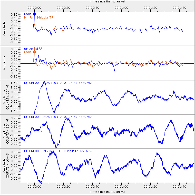
FURI Mt. Furi, Ethiopia - Earthquake Result Viewer
*The percent match for this event was below the threshold and hence no stack was calculated.
| Earthquake location: |
Near East Coast Of Honshu, Japan |
| Earthquake latitude/longitude: |
36.0/141.3 |
| Earthquake time(UTC): |
2011/03/12 (071) 03:11:57 GMT |
| Earthquake Depth: |
17 km |
| Earthquake Magnitude: |
5.7 MB |
| Earthquake Catalog/Contributor: |
WHDF/NEIC |
|
| Network: |
IU Global Seismograph Network (GSN - IRIS/USGS) |
| Station: |
FURI Mt. Furi, Ethiopia |
| Lat/Lon: |
8.90 N/38.68 E |
| Elevation: |
2570 m |
|
| Distance: |
94.9 deg |
| Az: |
284.608 deg |
| Baz: |
52.616 deg |
| Ray Param: |
$rayparam |
*The percent match for this event was below the threshold and hence was not used in the summary stack. |
|
| Radial Match: |
72.216034 % |
| Radial Bump: |
369 |
| Transverse Match: |
56.14347 % |
| Transverse Bump: |
400 |
| SOD ConfigId: |
356183 |
| Insert Time: |
2011-08-19 13:02:42.409 +0000 |
| GWidth: |
2.5 |
| Max Bumps: |
400 |
| Tol: |
0.001 |
|
Signal To Noise
| Channel | StoN | STA | LTA |
| IU:FURI:00:BHZ:20110312T03:24:47.372976Z | 0.26172736 | 1.3670905E-7 | 5.223338E-7 |
| IU:FURI:00:BHN:20110312T03:24:47.372976Z | 1.8699217 | 8.3674286E-7 | 4.4747483E-7 |
| IU:FURI:00:BHE:20110312T03:24:47.372976Z | 0.2804197 | 2.6729566E-7 | 9.5319854E-7 |
| Arrivals |
| Ps | |
| PpPs | |
| PsPs/PpSs | |


