You are here: Home > Network List > TA - USArray Transportable Network (new EarthScope stations) Stations List
> Station 633A Saathoff Ranch, Hondo, TX, USA > Earthquake Result Viewer
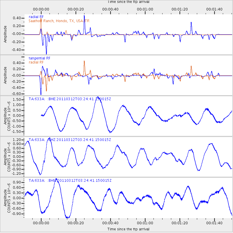
633A Saathoff Ranch, Hondo, TX, USA - Earthquake Result Viewer
*The percent match for this event was below the threshold and hence no stack was calculated.
| Earthquake location: |
Near East Coast Of Honshu, Japan |
| Earthquake latitude/longitude: |
36.0/141.3 |
| Earthquake time(UTC): |
2011/03/12 (071) 03:11:57 GMT |
| Earthquake Depth: |
17 km |
| Earthquake Magnitude: |
5.7 MB |
| Earthquake Catalog/Contributor: |
WHDF/NEIC |
|
| Network: |
TA USArray Transportable Network (new EarthScope stations) |
| Station: |
633A Saathoff Ranch, Hondo, TX, USA |
| Lat/Lon: |
29.46 N/99.18 W |
| Elevation: |
320 m |
|
| Distance: |
93.6 deg |
| Az: |
49.524 deg |
| Baz: |
314.952 deg |
| Ray Param: |
$rayparam |
*The percent match for this event was below the threshold and hence was not used in the summary stack. |
|
| Radial Match: |
78.24812 % |
| Radial Bump: |
334 |
| Transverse Match: |
49.774166 % |
| Transverse Bump: |
400 |
| SOD ConfigId: |
356183 |
| Insert Time: |
2011-08-19 13:23:24.512 +0000 |
| GWidth: |
2.5 |
| Max Bumps: |
400 |
| Tol: |
0.001 |
|
Signal To Noise
| Channel | StoN | STA | LTA |
| TA:633A: :BHZ:20110312T03:24:41.150015Z | 1.1209357 | 9.716358E-7 | 8.6680774E-7 |
| TA:633A: :BHN:20110312T03:24:41.150015Z | 1.8569939 | 6.1104424E-7 | 3.290502E-7 |
| TA:633A: :BHE:20110312T03:24:41.150015Z | 1.8790332 | 1.3261863E-6 | 7.057812E-7 |
| Arrivals |
| Ps | |
| PpPs | |
| PsPs/PpSs | |


