You are here: Home > Network List > TA - USArray Transportable Network (new EarthScope stations) Stations List
> Station 634A China Grove, San Antonio TX, USA > Earthquake Result Viewer
634A China Grove, San Antonio TX, USA - Earthquake Result Viewer

| Earthquake location: |
Near East Coast Of Honshu, Japan |
| Earthquake latitude/longitude: |
36.0/141.3 |
| Earthquake time(UTC): |
2011/03/12 (071) 03:11:57 GMT |
| Earthquake Depth: |
17 km |
| Earthquake Magnitude: |
5.7 MB |
| Earthquake Catalog/Contributor: |
WHDF/NEIC |
|
| Network: |
TA USArray Transportable Network (new EarthScope stations) |
| Station: |
634A China Grove, San Antonio TX, USA |
| Lat/Lon: |
29.38 N/98.35 W |
| Elevation: |
188 m |
|
| Distance: |
94.1 deg |
| Az: |
49.067 deg |
| Baz: |
315.386 deg |
| Ray Param: |
0.041112255 |
| Estimated Moho Depth: |
69.75 km |
| Estimated Crust Vp/Vs: |
1.69 |
| Assumed Crust Vp: |
6.347 km/s |
| Estimated Crust Vs: |
3.767 km/s |
| Estimated Crust Poisson's Ratio: |
0.23 |
|
| Radial Match: |
84.95654 % |
| Radial Bump: |
400 |
| Transverse Match: |
69.06774 % |
| Transverse Bump: |
400 |
| SOD ConfigId: |
356183 |
| Insert Time: |
2011-08-19 13:23:24.939 +0000 |
| GWidth: |
2.5 |
| Max Bumps: |
400 |
| Tol: |
0.001 |
|
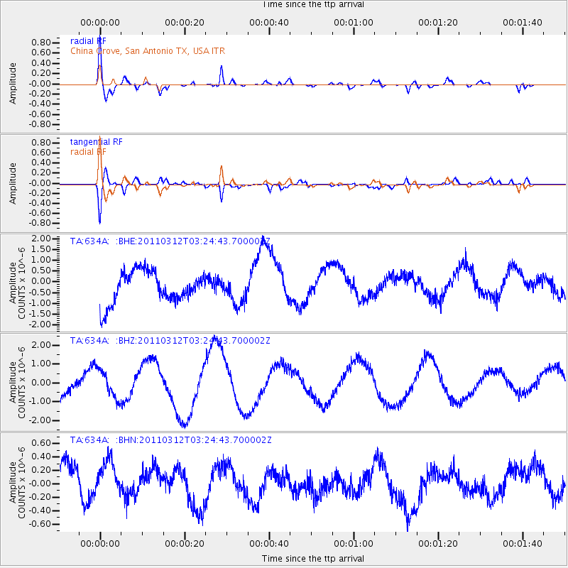
Signal To Noise
| Channel | StoN | STA | LTA |
| TA:634A: :BHZ:20110312T03:24:43.700002Z | 0.9860257 | 7.2695866E-7 | 7.372614E-7 |
| TA:634A: :BHN:20110312T03:24:43.700002Z | 1.2301346 | 3.1508438E-7 | 2.5613815E-7 |
| TA:634A: :BHE:20110312T03:24:43.700002Z | 0.8822618 | 6.3331123E-7 | 7.178269E-7 |
| Arrivals |
| Ps | 7.7 SECOND |
| PpPs | 29 SECOND |
| PsPs/PpSs | 37 SECOND |


